The Book of Dow: Surveys
A comprehensive study of Dow Cave, Kettlewell, by Steve and Patrick Warren
The
pages below are under development and will be updated on a regular
basis.
All images are from the author's collection unless otherwise indicated.
Click on images for larger view: use back arrow to return from image view.
These pages concern the surveys made over the past years since a start was made on the complete resurvey of Dow Cave in 1982. A great number of people have helped with this work and further information will be found in later sections.
Prints from surveys online will be available in due course. Meanwhile hard copies of all surveys are available at cost from the author. Please enquire using the e-mail address below.
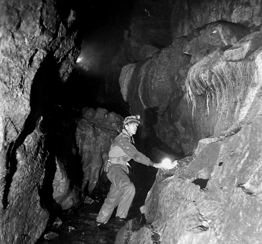
Left: the author in Dow Cave c 1960.
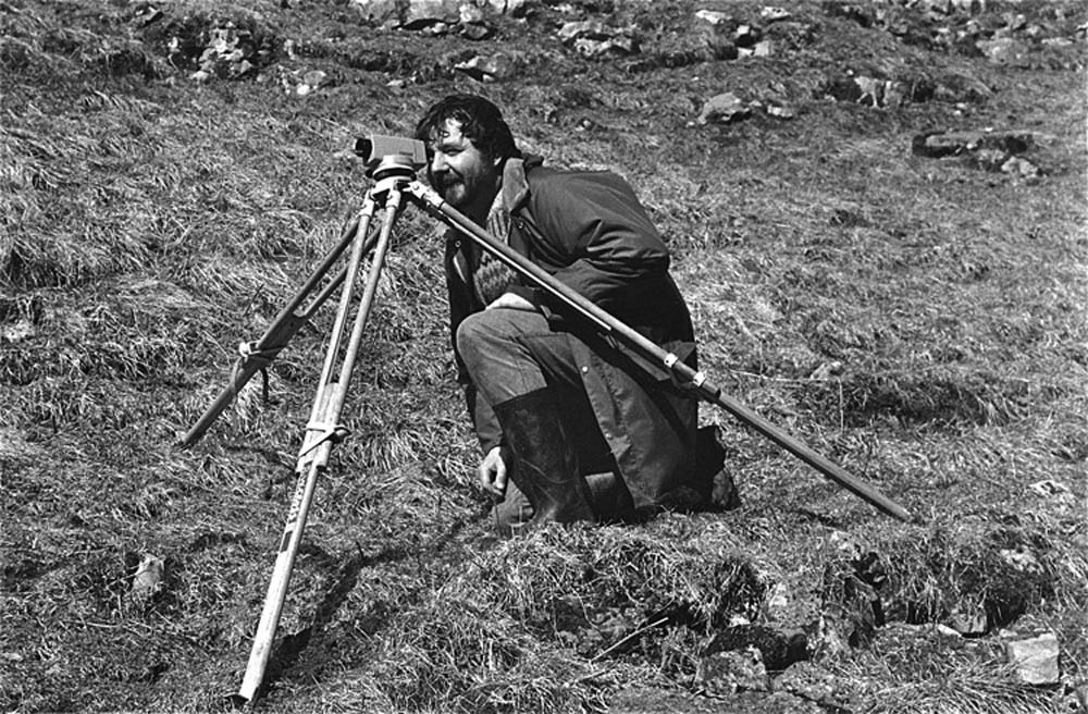
During the Easter Week camp of 1986 Bob Cross levelled up to Dow Cave entrance from a OS bench mark at Park Rash which gave the altitude of the entrance at 333.8m, and of 379.87m for the point where the fence line crosses Caseker Gill. Photo SEW April 5, 1986.
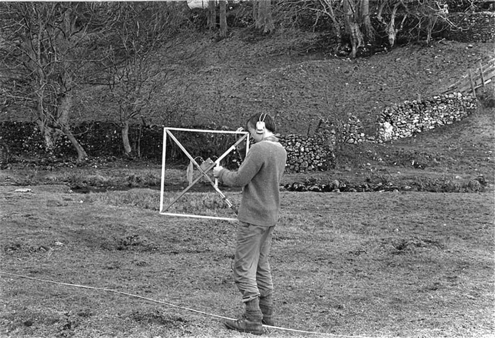
In the same week several sites were identified as suitable for "radio location" using a magnetic induction device. Patrick Warren is shown calibrating the device on a flat field at the foot of Dowber Gill. Photo SEW March 31 1986 .
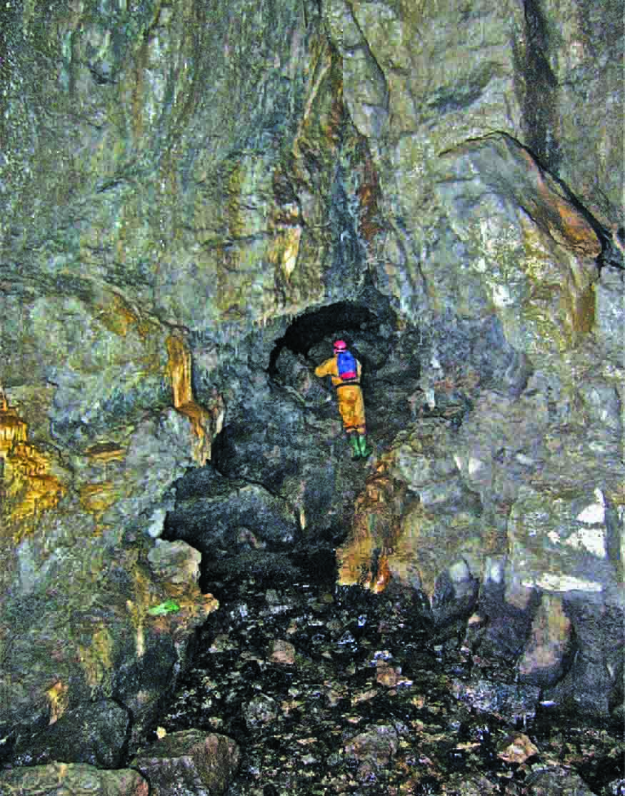
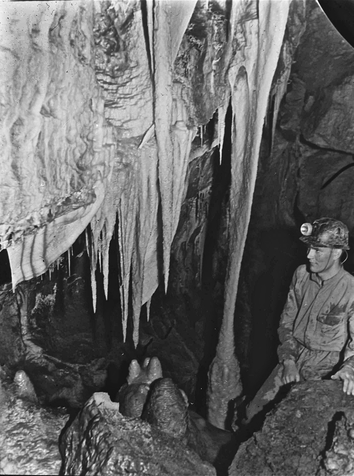
At "The Triple Oxbow"; a hypogenic section of the main streamway in the 1953 Caseker Gill extension to Dow Cave.
Introduction
In June 1953, an engineer from Keighley thought it would be a good idea to spend a day exploring Dow Cave near Kettlewell: it happened to be Tuesday, June 2 - Coronation Day. John Hobson: “On the Tuesday of Coronation week, I entered Dow Cave, a venue dictated because I was alone and without tackle. After reaching the end of the known section, an easy enough walk, I attempted to follow the stream under the boulders but the way was too tight. My attention was then drawn to crevices on the right and, in one of them, there was a draught although a rockfall barred entry. On June 28th I returned to Dow Cave, this time with a friend, a crowbar, and the adage “Where there's a wind, there's a way’”.
The rest of the story not only became caving history, it engendered a whole new school of exploration around Kettlewell, principally by Hobson’s fellow members of the Craven Pothole Club. Within the next three weeks some quite remarkable passages had been explored in the “Caseker Gill Extension” with a grand stream passage, cascades, a great profusion of stalactite and stalagmite formations, flowstones and crystal pools, but with many secluded corners some of which to this day conceal hidden gems. By the end of the following year yet another mile or so of new passages had been explored, not only from the end of the known cave, but from a previously little known side passage first recorded, in fact by members of the Burnley Caving Club and referred to as “PG Passage”. This was the now infamous Dowber Gill Passage leading to what is in essence the completely separate cave system of Providence Pot.
Fig.1 shows the general geography of the area around Dow Cave entrance and Fig.4 some aspects of the geology. Norman Thornber’s original, and somewhat misleading, description of Douk Cave, Kettlewell (also called Dow Cave) in Pennine Underground, 1947. stated: "Once an old lead mine, but a very good cave. A ledge can be followed for some distance, but stream has to be entered. Roof lowers to four feet, stream flowing between thirty feet wide silt bed. Three hundred yards in on the left, mine level can be seen. Main passage ends in chamber thirty feet high, thirty feet wide, and fifty feet long".
Dow Cave is a most remarkable cave in its own right with a wide variety of features that are helpful in understanding how this cave and others in the vicinity have been formed and developed on the geological time scale. It is a wonderful cave with many outstanding features, well worth a visit by the connoisseur of the unusual.
Records of Dow Cave prior to 1953 are almost non-existent other than some often fanciful accounts from writers and travellers of the Victorian and Edwardian eras. The entrance is hidden away in a limestone scar in the otherwise rarely visited Caseker Gill, itself a place of great interest, not only to the rock-hound, but also to any nature lover. Fig 2 shows the location of Dow Cave but it is difficult of access by any standards and there are no footpaths beyond that leading to the cave entrance. Certainly the lead-miners of the 17th century knew all about this cave: they were following a mineral vein, Caseker Gill Vein, both from the surface above the cave and from inside the cave itself. This vein contained workable quantities of the valuable mineral galena, a rich source of lead and much sought after for water pipes and roofing sheets for the incipient industrial revolution. The attached plans show the extent to which these miners have exploited the resources of the area. Unfortunately, there seems to be very few records of their activities in or around Dow Cave in the mining records although such records do exist for many of the nearby gills and moorlands: For example the Old Providence Vein was exploited from Dowber Gill, and well documented, and the remains of the Kettlewell smelt mill show that lead mining activity once played an important part in the economy of the area.
Fig 3 illustrates the location of some of the mined areas and Fig 18 shows the location of mined areas seen in Dow Cave.
Some other caves in the area such as Scoska Cave and Dowkabottom Cave did receive attention from early explorers. Dowkabottom was the location of a major archaeological exploration in the middle of the 19th Century when large quantities of human and animal remains, and artifacts, were excavated. Scoska Cave also attracted much interest as we are reminded when we see inscriptions on the wall inside the cave by William Coates of Mile House dated 1841 and Henry Dean of Litton dated July 21, 1845.
The 18th Century archaeologists also investigated Heights Cave near Bordley and Elbolton Cave near Cracoe.
An early account of Dow Cave came from William Howson in 1850 when he wrote of Dow Cave as “a series of lofty chambers, narrow passages and several branch passages”. A little later B J Harker of Grassington wrote: “Somewhere about 1852, another cavern which is called Douk Cave was discovered ………its height is from three to 20 yards and its breadth 20 yards and upwards. You may walk in an upright position through most of its passages: down the middle flows a pellucid stream and from the top and sides hang numberless petrifactions of the most grotesque shapes. A human skeleton was found in it …”
Later In the 19th Century those two prodigious writers on the Yorkshire countryside, Harry Speight and Edmund Bogg, travelled far and wide in the search for the unusual and the curious. Dow (Douk) Cave did not escape their attention although it is only fair to say that much of what they wrote came from local hearsay and maybe even imagination. However at that time some of the lead-miners were still around and they often were able to relate first-hand and, perhaps, second-hand tales of the underworld.
Thus Harry Speight wrote of two caverns called Douk and Dove Caves…..” all sort of stories are current concerning them. In Douk Cave, I have actually been told, a whole regiment of skeletons has been found. Douk Cave contains many branch passages and several large chambers and may be explored a considerable way. It has a very picturesque and spacious entrance, situated on the western buttress of Great Whernside”.
Edmund Bogg, “T’owd Chief” of the “Savages” of the Leeds based Thoreseby Society excelled himself with this… “a remarkable provision of caveland… in a most romantic ravine. The dome of the cave is one large mass of limestone, the height varying from 15 to 25 feet, by 20 feet in width. A stream flows through the centre; walking along its bed is the best way of examining the interior. The cave has been explored for several hundred yards, but is said to extend far under Whernside. The cavern has been formed partly by the washing away of the earth during the course of ages and partly by mining. During our last visit we found the entrance to the cave had altogether changed in aspect, the roof had fallen in; there was, however, abundance of water everywhere”.
and then:
“The wild and picturesque glen we have been following closes up abruptly at the entrance to the cave, around which, in utter confusion, tons of rock are strewn, covered with moss and dense foliage. The sides of the glen are lined with mountain ash and other trees. A few yards to the left of the entrance is a most lovely waterfall of some twenty feet into a circular basin, perfectly sculptured by Nature, This wild ravine, with its rocks and caverns, leaping waters, and lovely cascade seen through a leafy screen, is very romantic”
Edmund Bogg goes on to relate a novel concert in Douk Cave in the Autumn of 1891. “The company numbering about thirty-five started soon after dusk from Kettlewell, provided with candles and magnesium wire. After much fun in wading through torrents and falling over rocks the party landed safely in the cave and not one we should imagine will soon forget its weird and gloomy depths."
Meanwhile, in the late 19th Century and early 20th Century, the Yorkshire Ramblers Club, primarily a mountaineering club, did take an interest in exploring caves and in recording and making surveys of their explorations. G T Lowe, an early President of the Club had already made a realistic plan of Hell Hole near Skyreholme.
Edmund Bogg mentions an account of Dow Cave by G T Lowe: “The passage has often been traversed and is pretty nearly denuded of its best stalactites but still presents many interesting features. One of the most remarkable is an arch within the entrance formed of three large fallen blocks of stone which have met in such a manner that a natural bridge is the result. It is best to take to the water at once and wade directly in the stream which soon becomes clear of the precipitous rocky sides and flows over beds of silt, or disappears at times under rough heaps of boulders. We examined many lateral passages, including one of considerable length on the North side about 350 yards from the entrance. Keeping to the main channel we were eventually stopped at a point where the water issues from a narrow cleft amongst a heap of jagged rocks. No possible means of continuing the journey could be discovered. From here we found the actual distance to the mouth of the cave to be about 450 yards. There are no serious difficulties in the entire passage .... many indications of previous visitors will be found, and several signs of mining operations”.
However, in 1949, John Balderston of Kettlewell did produce a realistic map of Dow Cave containing some original observations: see Fig. 5.
John Hobson at "The Angel" in the Dow Cave extension first discovered by John in June 1953
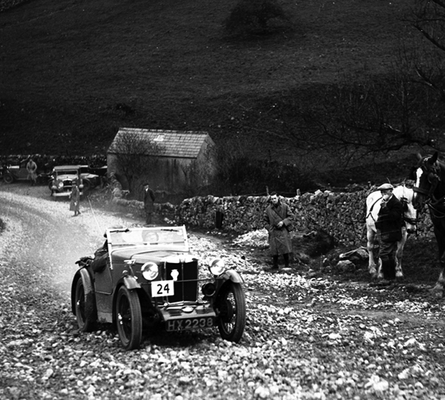
Dow Cave, in a remote corner of Wharfedale, was a long way from the traditional potholers’ hunting grounds around the Three Peaks and it was not often visited but, in the 1930’s, Park Rash, the nearest road access to Dow Cave, was a very popular venue for the motor sport enthusiasts. Having a gradient of 1 in 3 on the steepest bend, and being un-surfaced until the late 1940’s, it was one of the great challenges for the “Hill-climb” enthusiasts. The attached image from those days was very kindly provided by Chris Lambert of ‘Pre-war Minor Network’, courtesy of Zoe Schafer of ‘Motor Sport Images Ltd’.
References
Bogg, Edmund, 1904, "Higher Wharfeland : the Dale of Romance," pub. Leeds 1904.
Crunden R L, 1953, Bibliography, Craven Pothole Club Journal 1/5 1953, pp225-9
Denny H, 1859, “On the Geological and Archaeological Contents of the Victoria and Dowkerbottom Caves in Craven”
Proc. Yorks. Geol. Soc. 4, 45-74 1859
Farrrer J, 1865, “Further Explorations in the Dowkerbottom Cave in Craven” Proc. Yorks. Geol. Soc. 4, 414-422.
Gill M. C. 1994, “The Wharfedale Mines”: British Mining No. 49, 1994
Harker, B. J. 1869 "Rambles in Upper Wharfedale," pub. Skipton 1869
Howson, William: 1850, "An Illustrated Guide to the Curiosities of Craven," pub. London.
Jones Rev E 1890, “On the Recent Exploration of a Cave at Elbolton near Thorpe” Proc. Yorks. Geol. Soc. 11, 307-310. Elbolton Cave 1890
Poulton E B 1881, “A Preliminary Report of the Working of Dowkerbottom Cave during August and September 1881” Proc. Yorks. Geol. Soc. 7, 351-367
Speight, Harry, 1892 "The Craven and North West Yorkshire Highlands,"
Thornber N. 1947 “Pennine Underground”
Warren S E, 1983, “P.G.' not ‘D.G.” CPCJ 6/4 1982-83 pp194-5
Warren S E, 2019, “Cave Surveys from the Yorkshire Dales”
Fig. 1: Annotated image of the area around the entrance to Dow Cave
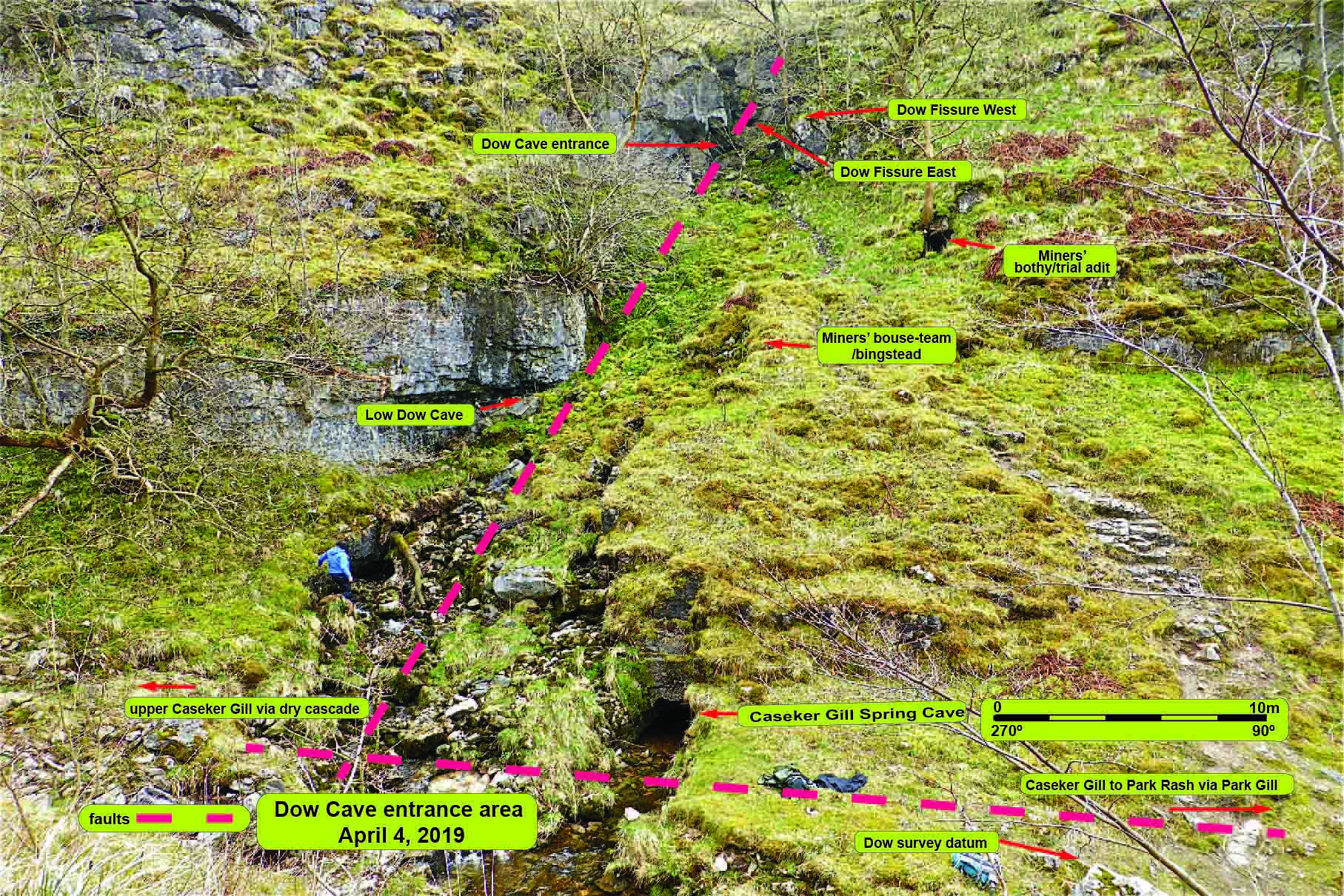
Fig. 2 Dow Cave: Entrance area and Low Dow Cave
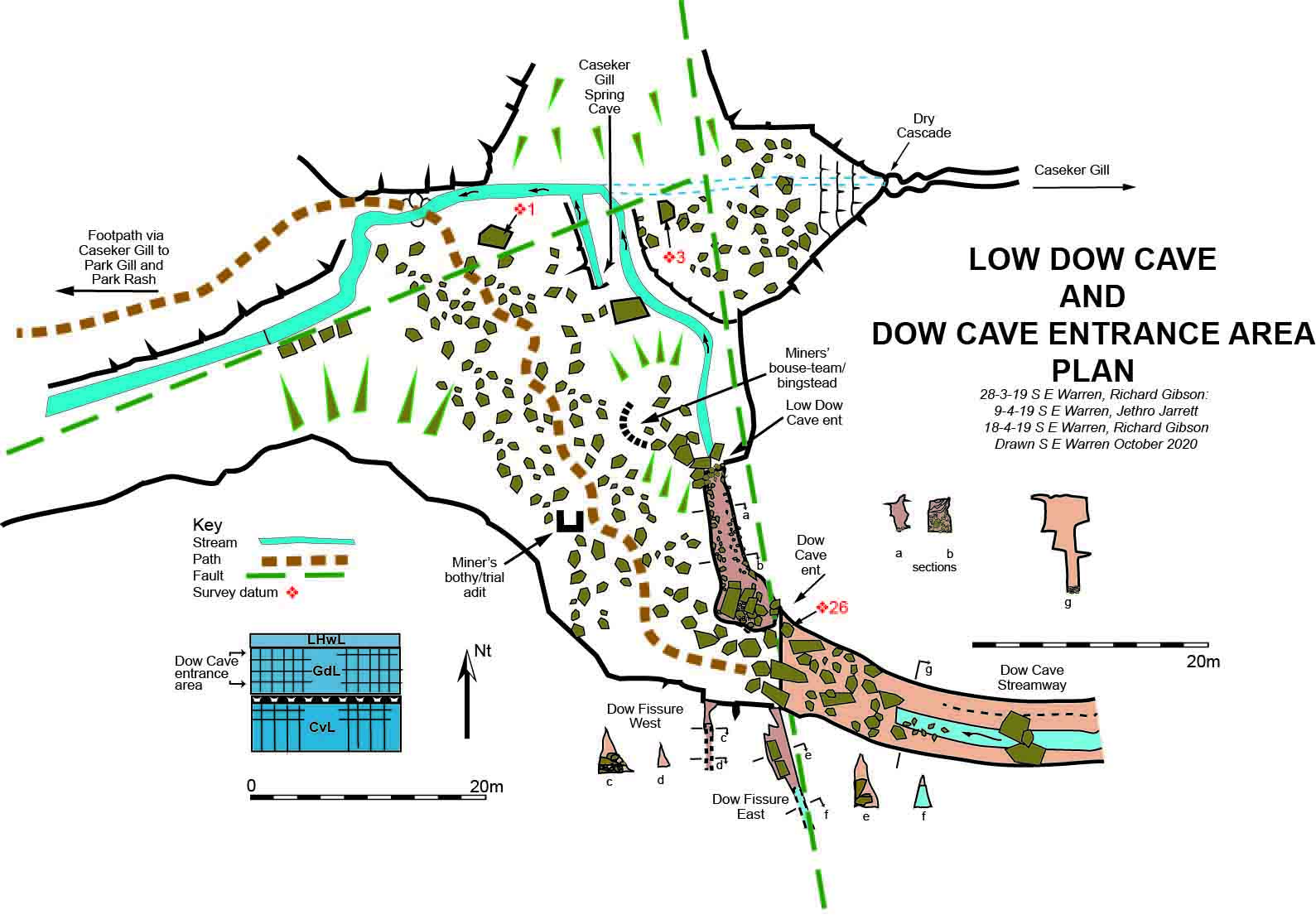
Fig. 3: The Kettlewell - Dow Cave area
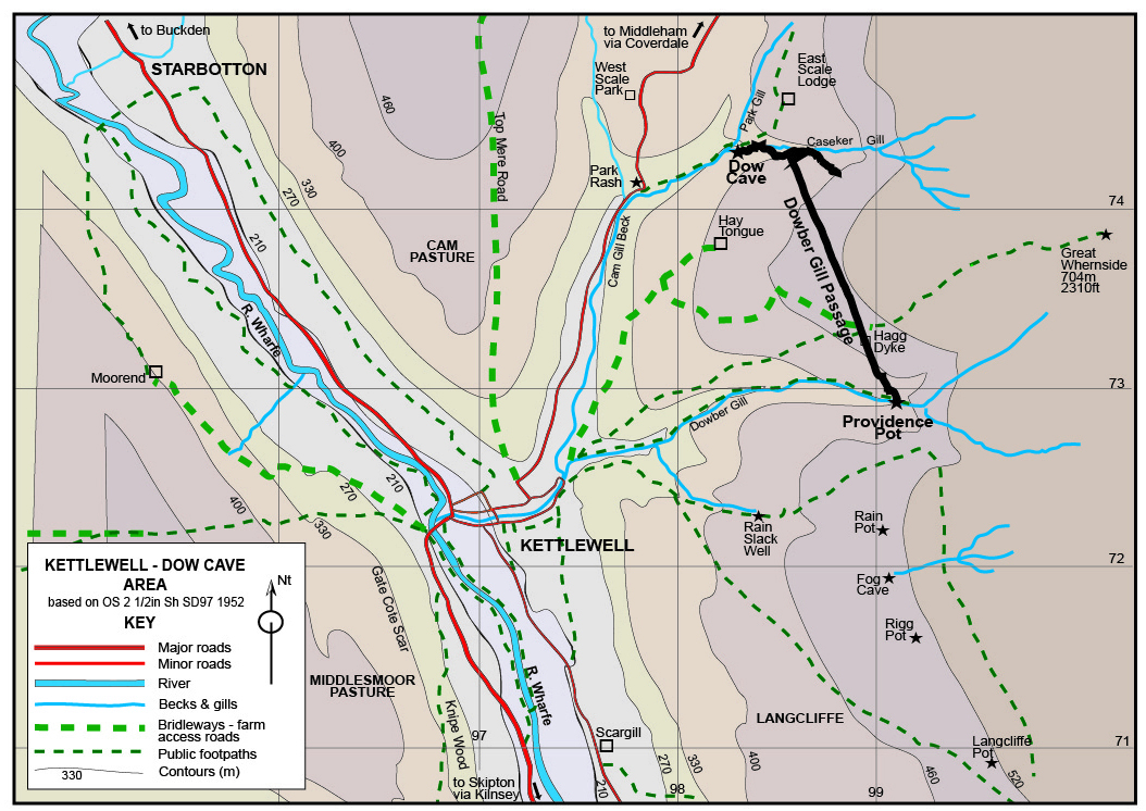
Fig.4: Kettlewell - Dow Cave area outline map
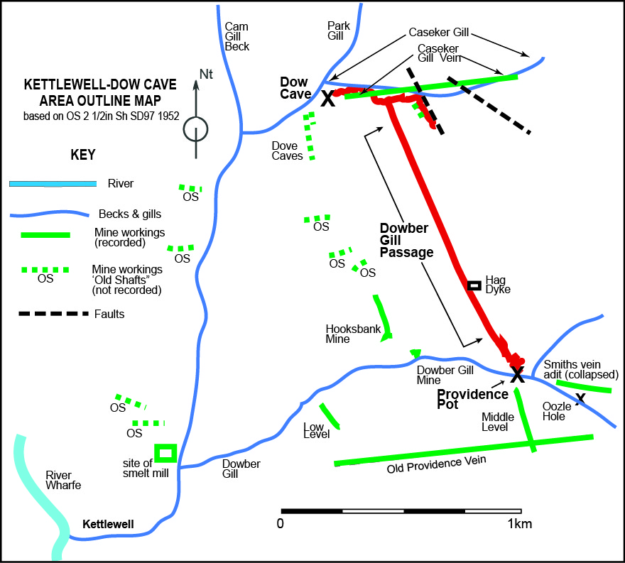
Fig. 5: General representation of the geology and the terrain around Dow Cave.
Based on an original idea from Patrick Warren
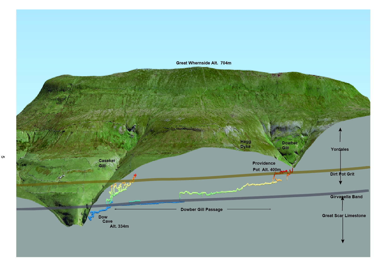
Fig.6: Balderston's 1949 sketch map of Dow Cave
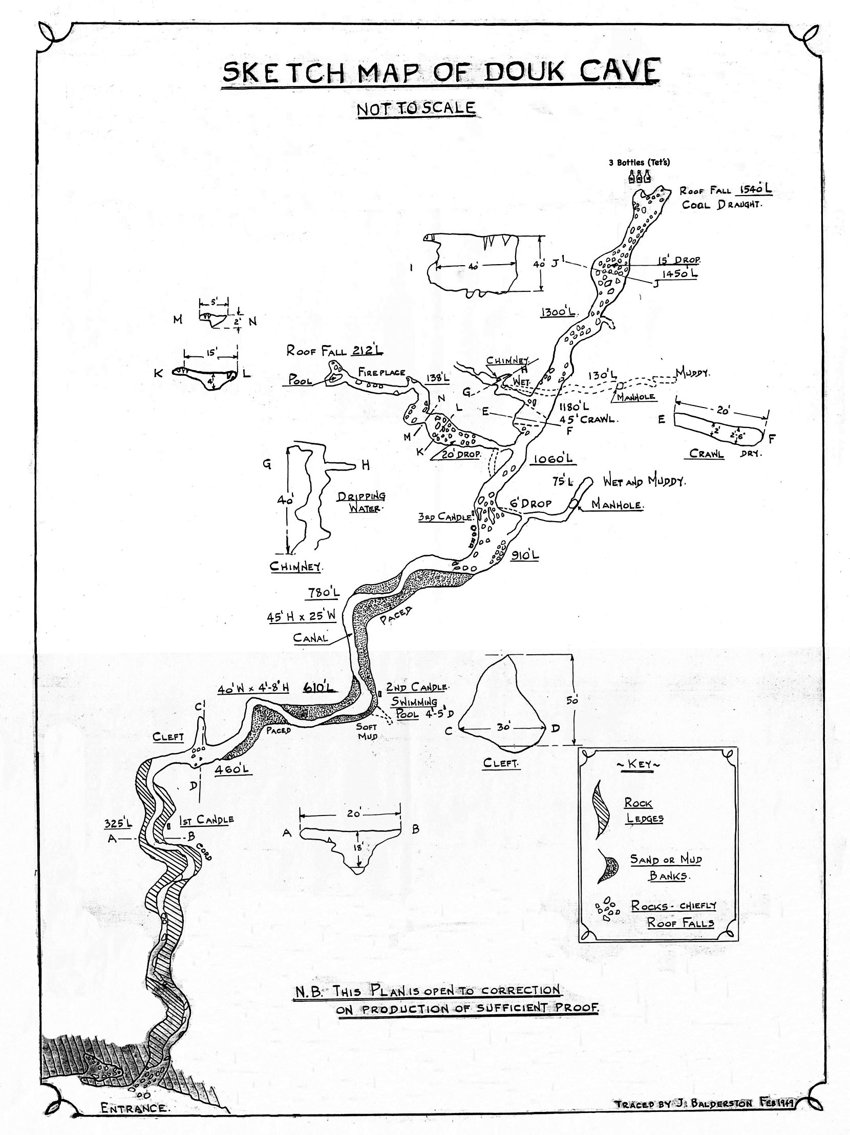
Fig.7 Plan and elevation of Dow Cave made by 6th. Bingley 1st Harden and Wilsden Scouts 1974
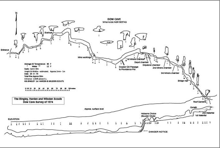
Fig. 8 The 1953 plan of Dow Cave including the Caseker Gill Extension. Made by Dennis Brindle et. al.
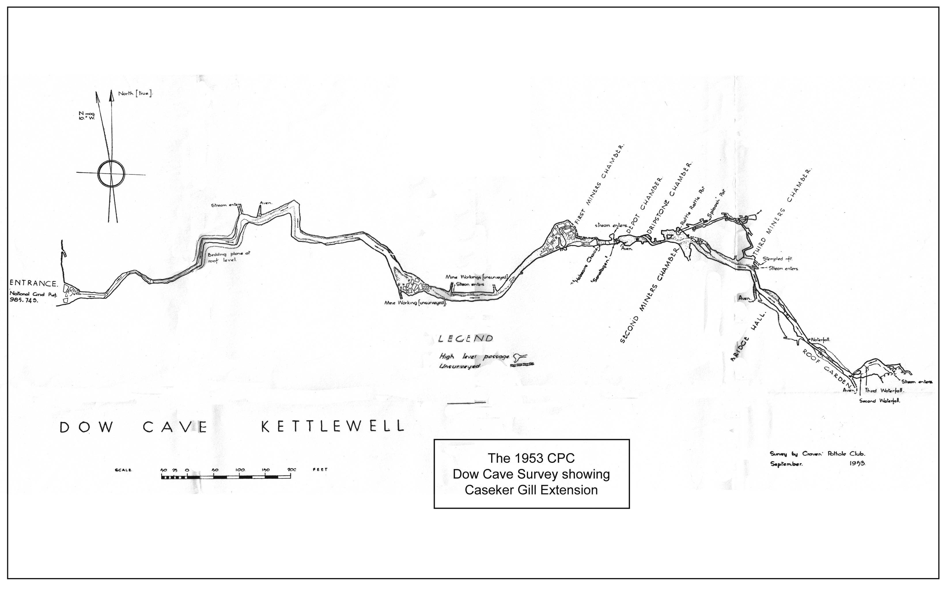
Fig. 9 Dow Cave: plan and elevations- all
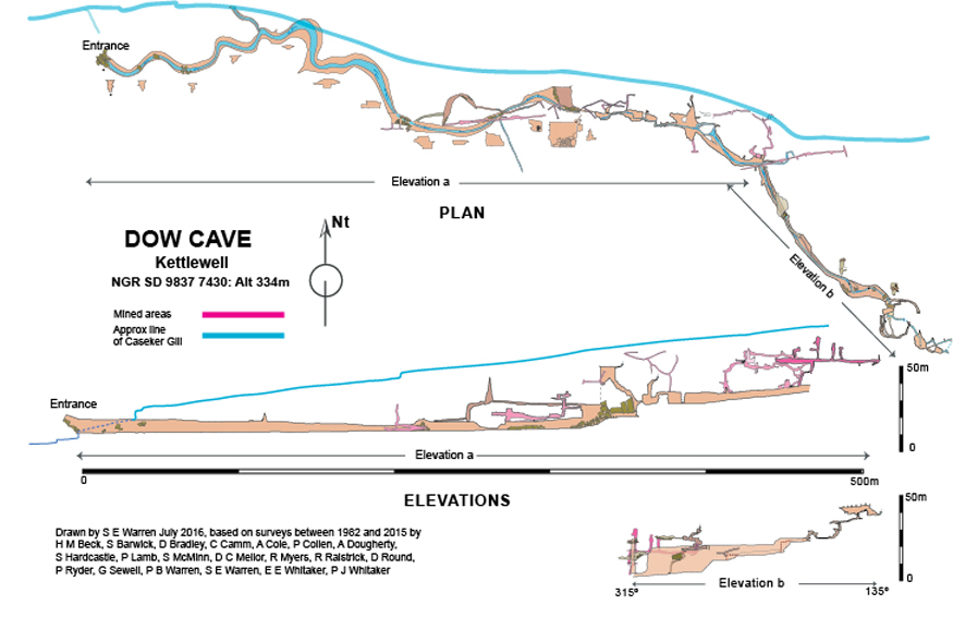
Fig. 10 Dow Cave: block plan showing the four parts seen below
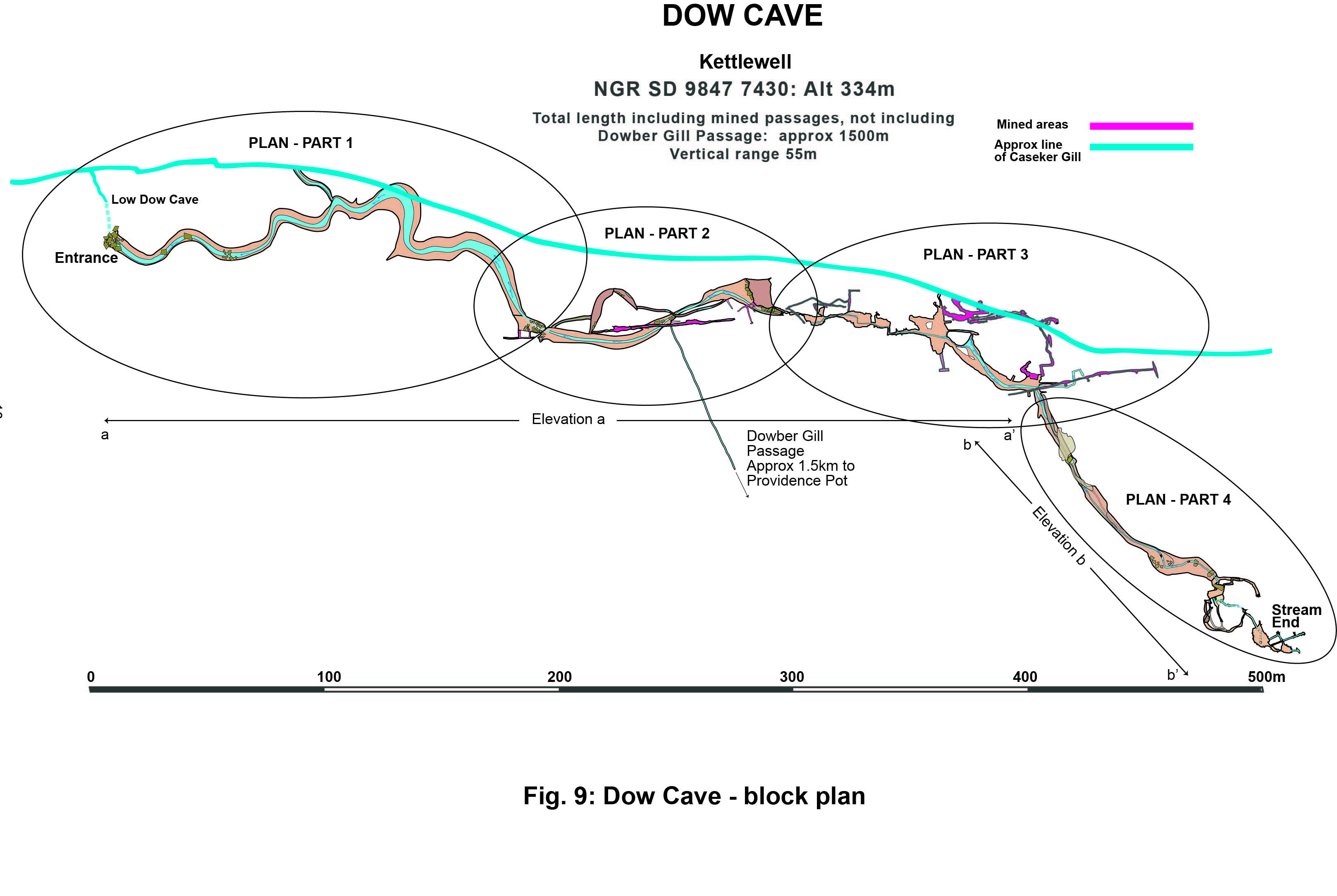
Fig. 11 Dow Cave Plan Part 1
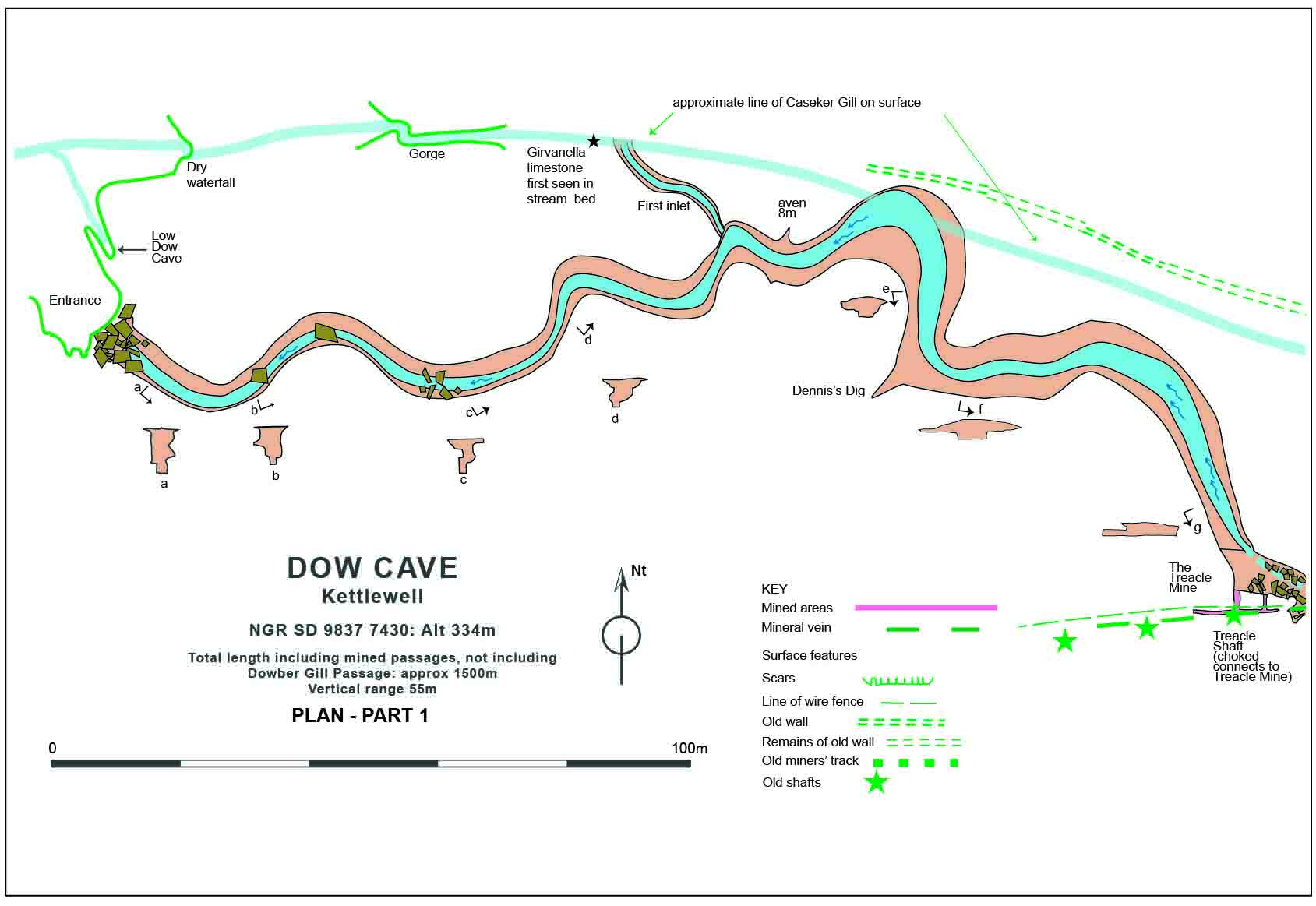
Fig. 12 Dow Cave Plan Part 2
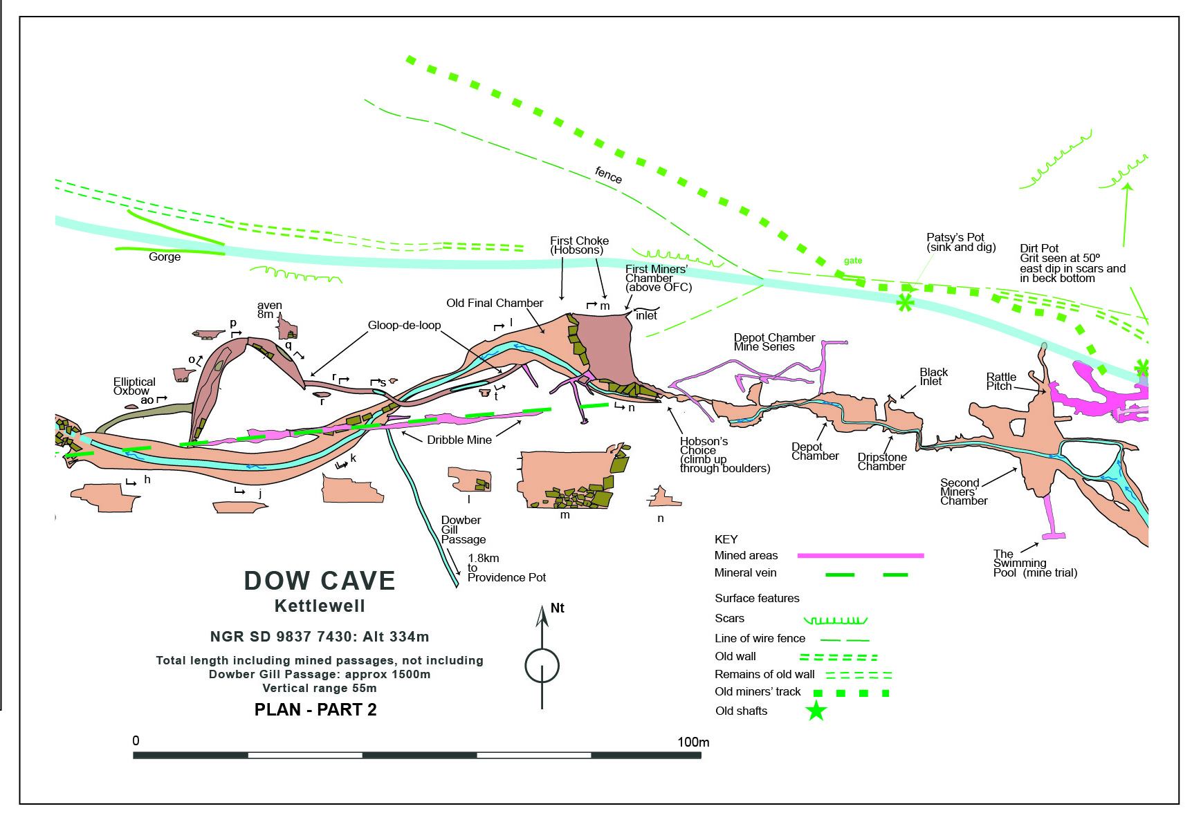
Fig. 13 Dow Cave Plan Part 3
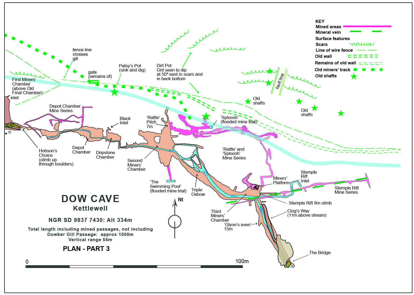
Fig. 14 Dow Cave Plan Part 4
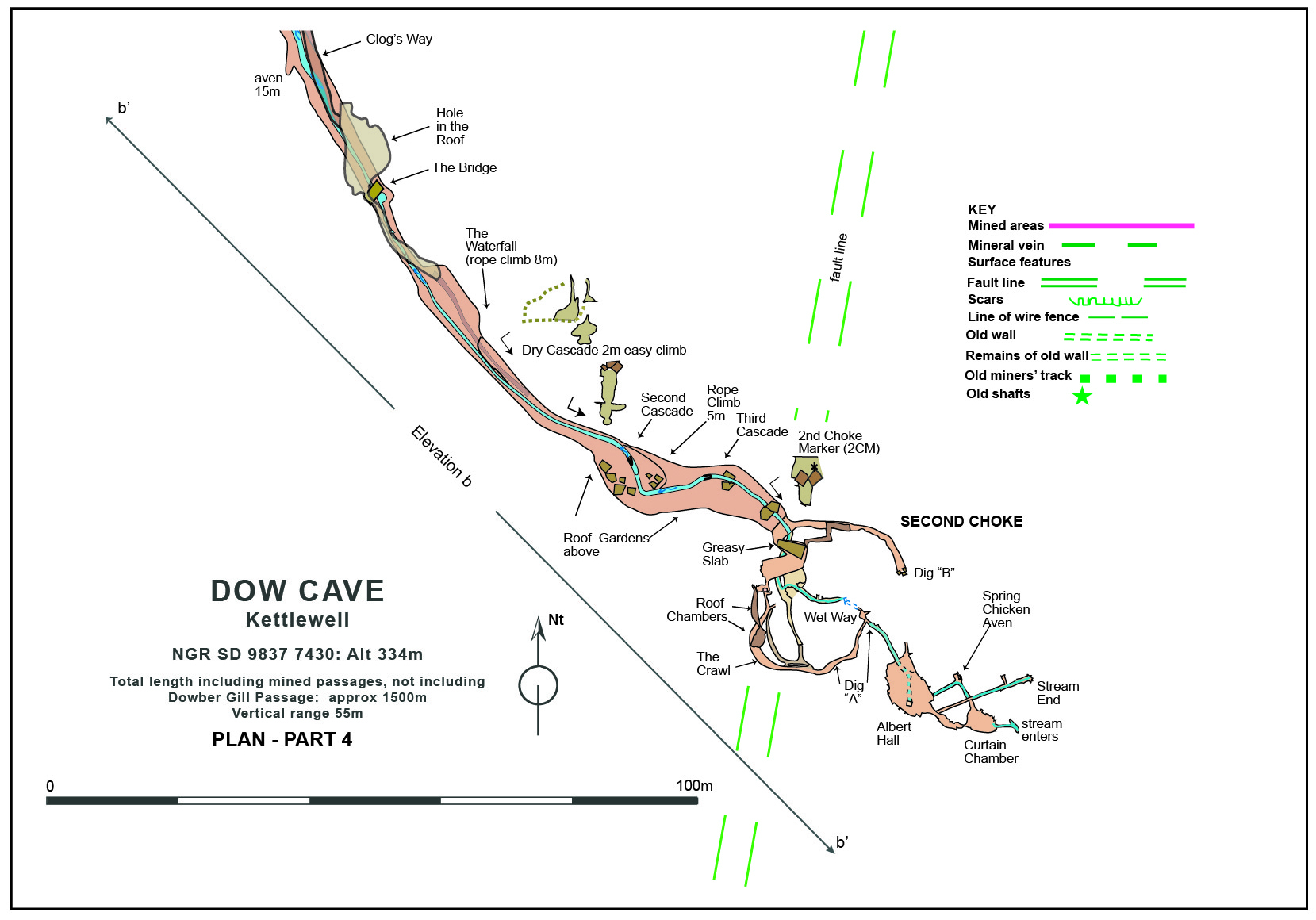
Fig. 15 Dow Cave Elevation Part 1
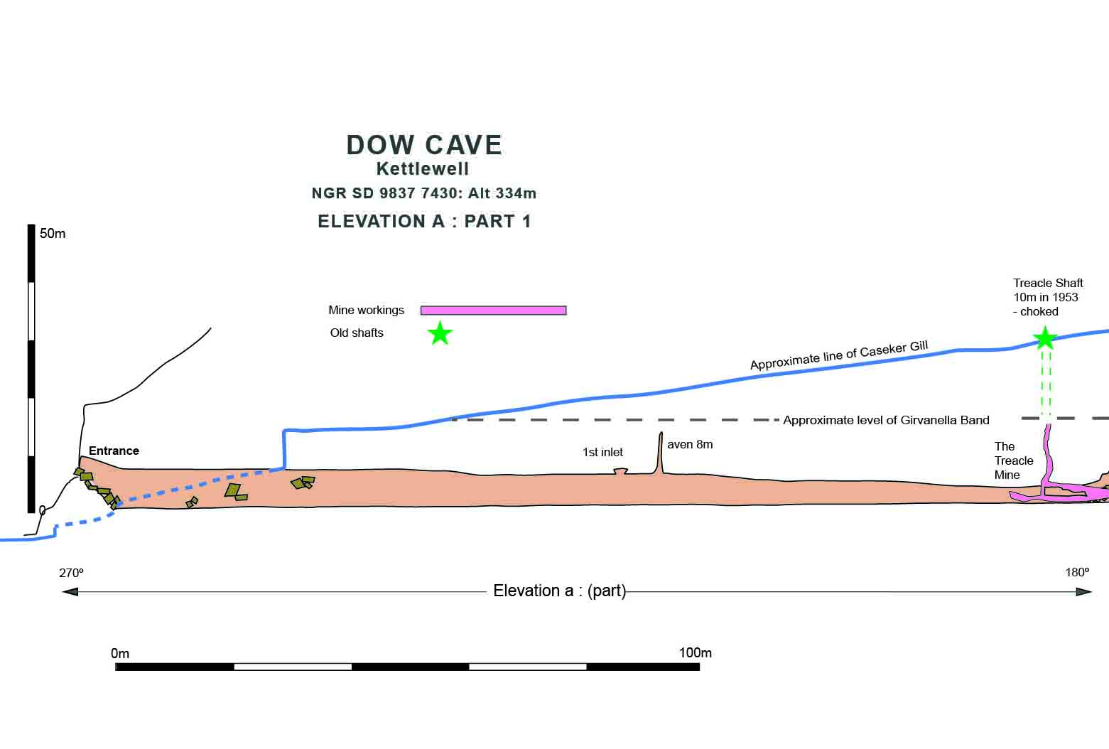
Fig. 16 Dow Cave Elevation Part 2
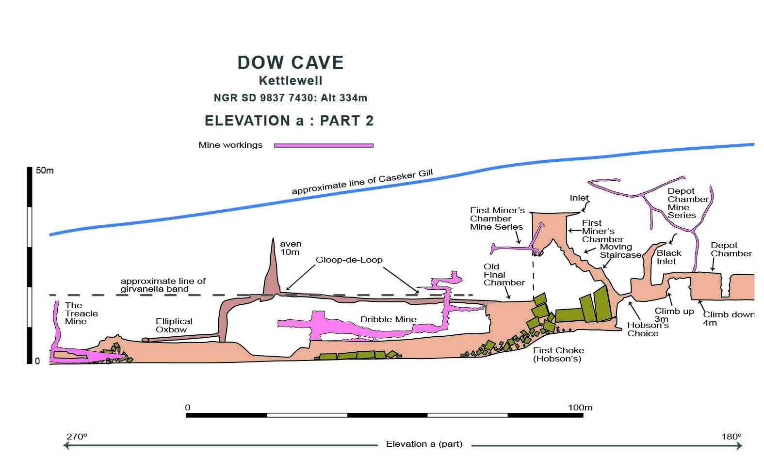
Fig. 17 Dow Cave Plan Elevation Part 3
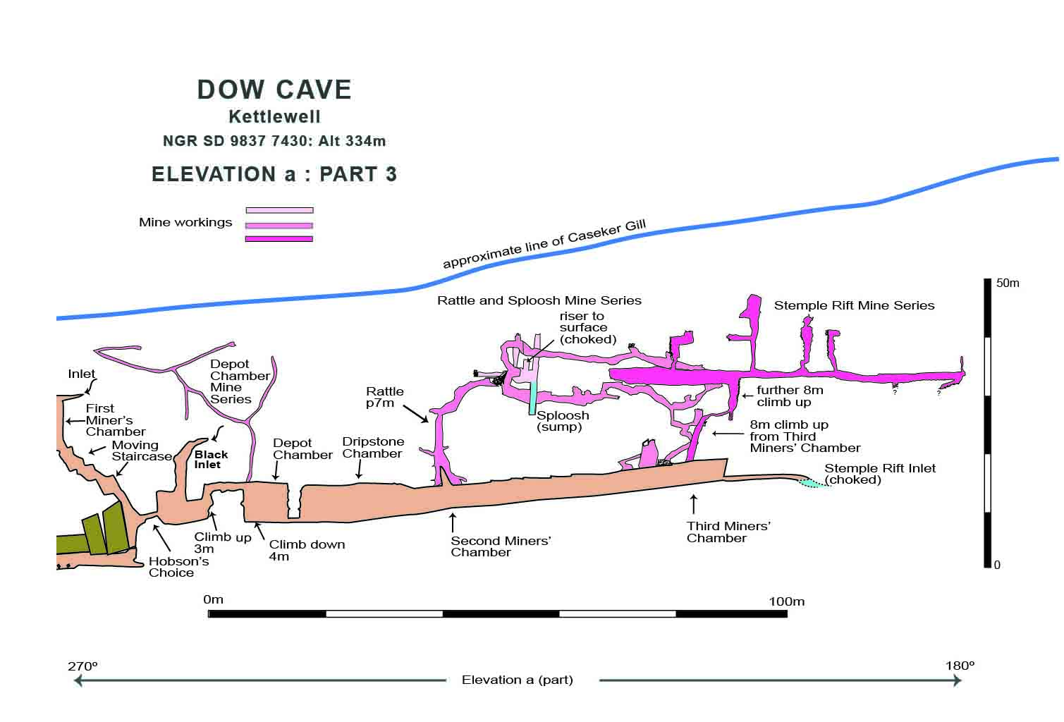
Fig. 18 Dow Cave Elevation b
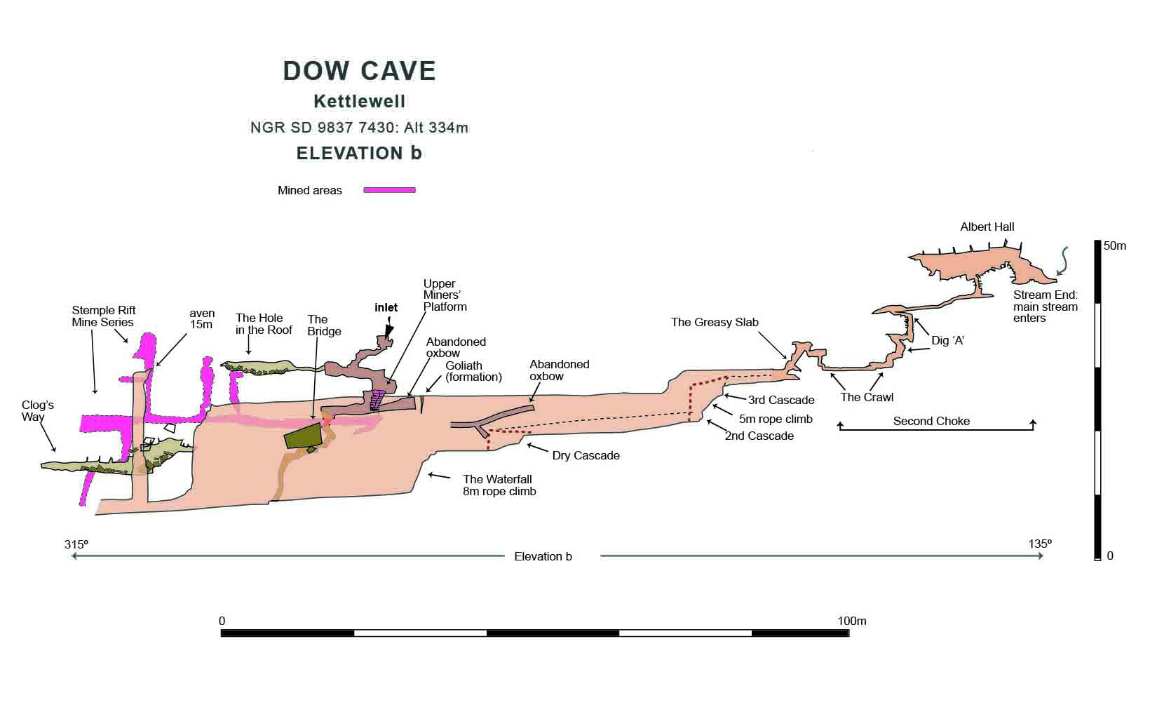
Fig. 19 Dow Cave: Mined areas
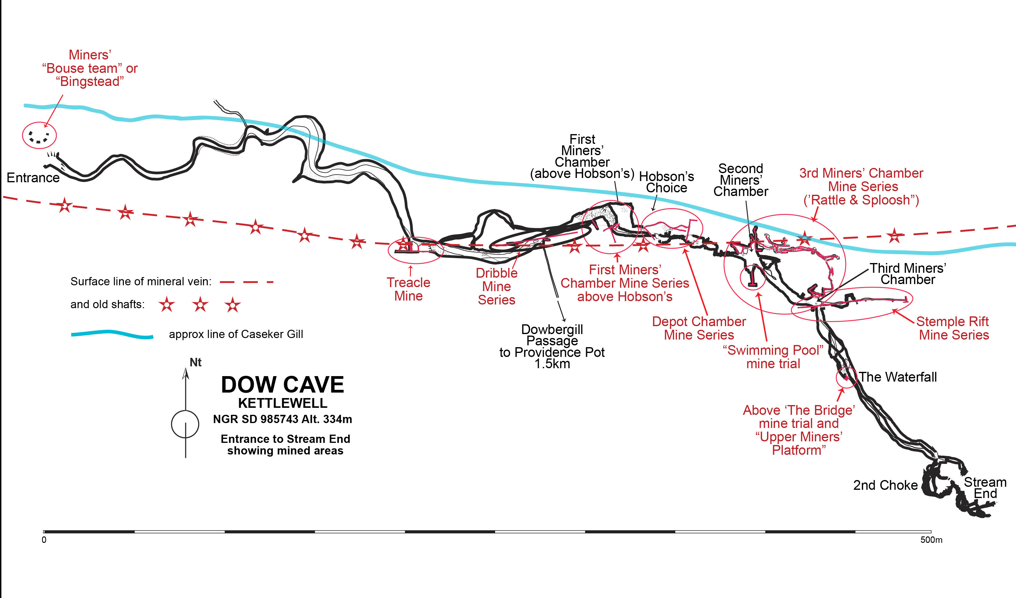
Fig. 20 Dow Cave: Depot Chamber Mine Series and Above Hobsons
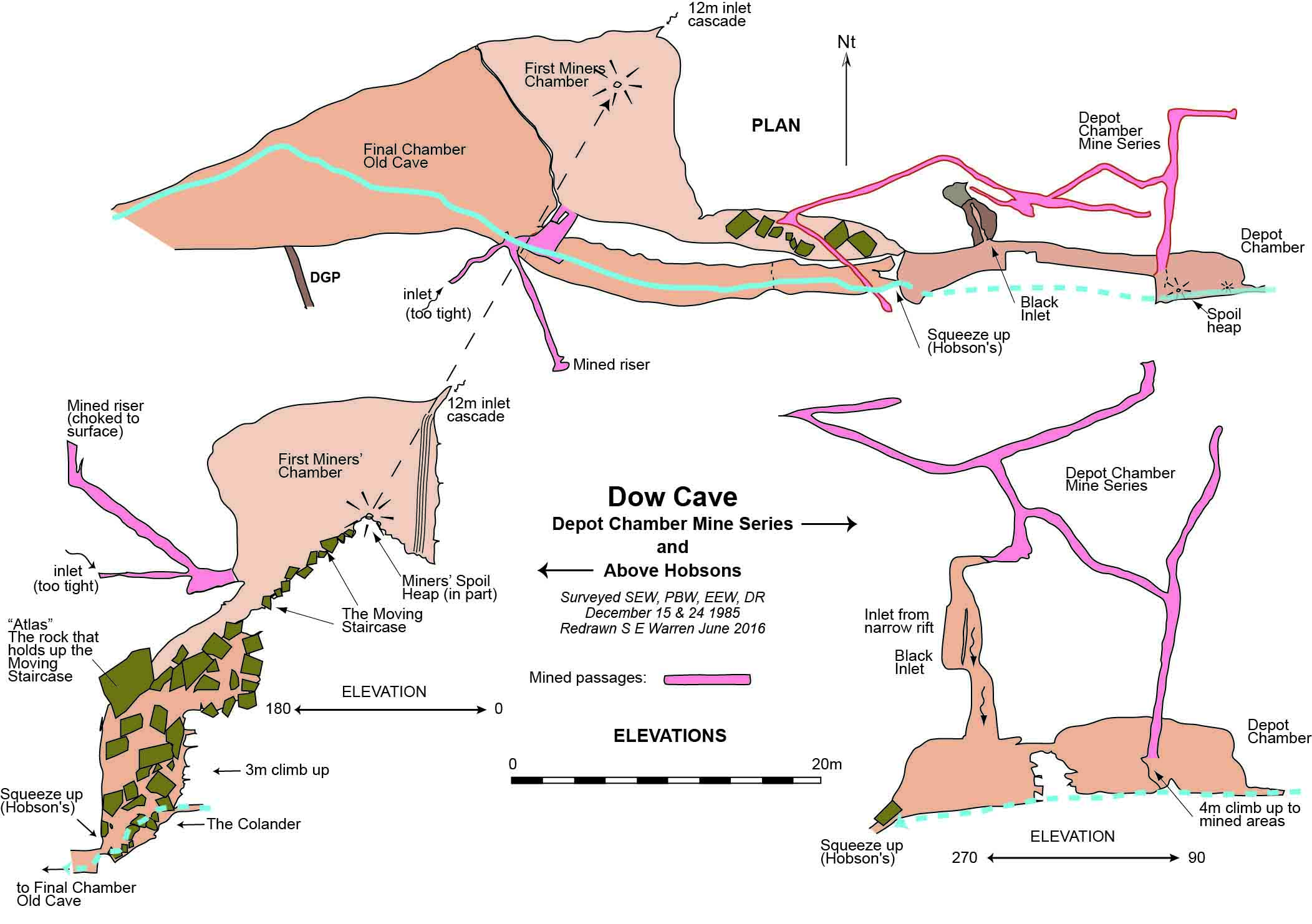
Fig. 21 Dow Cave: Dribble Mine
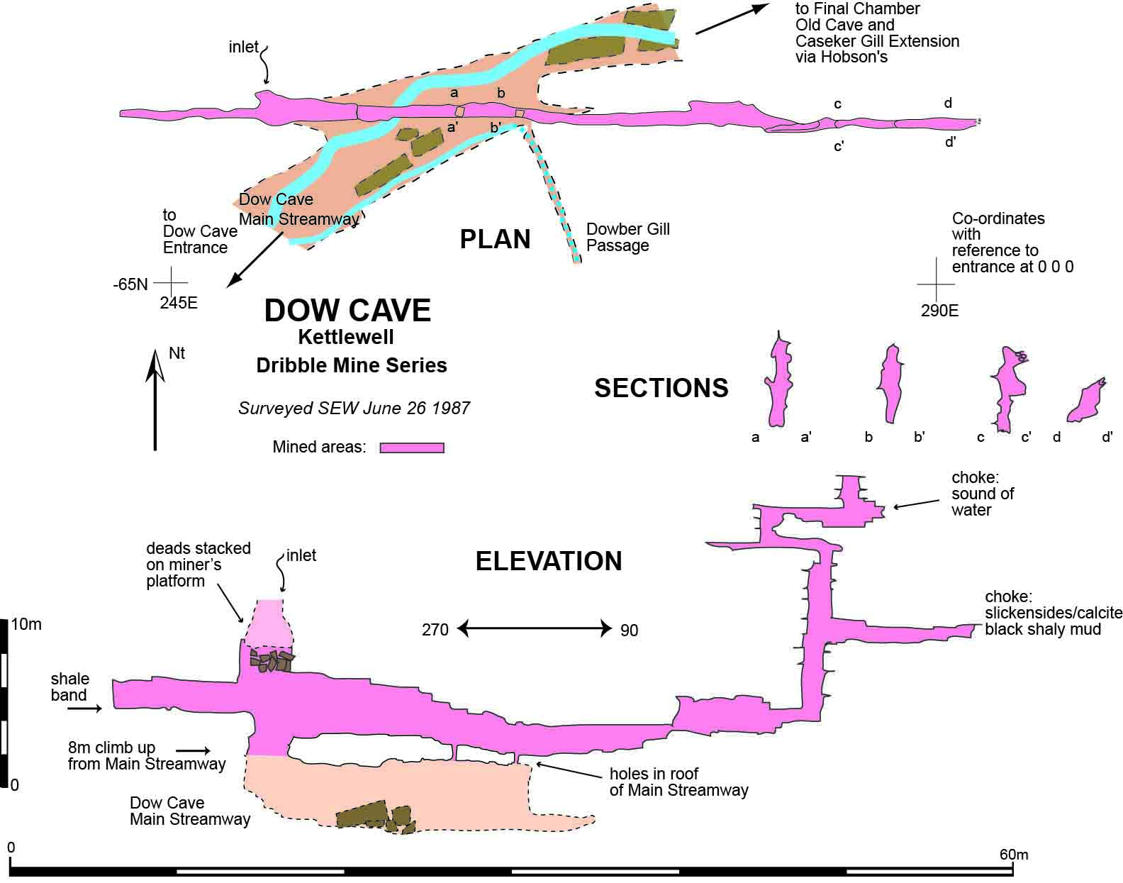
Fig. 22 Dow Cave: Rattle and Sploosh - Third Miners Chamber Mine Series - Plan
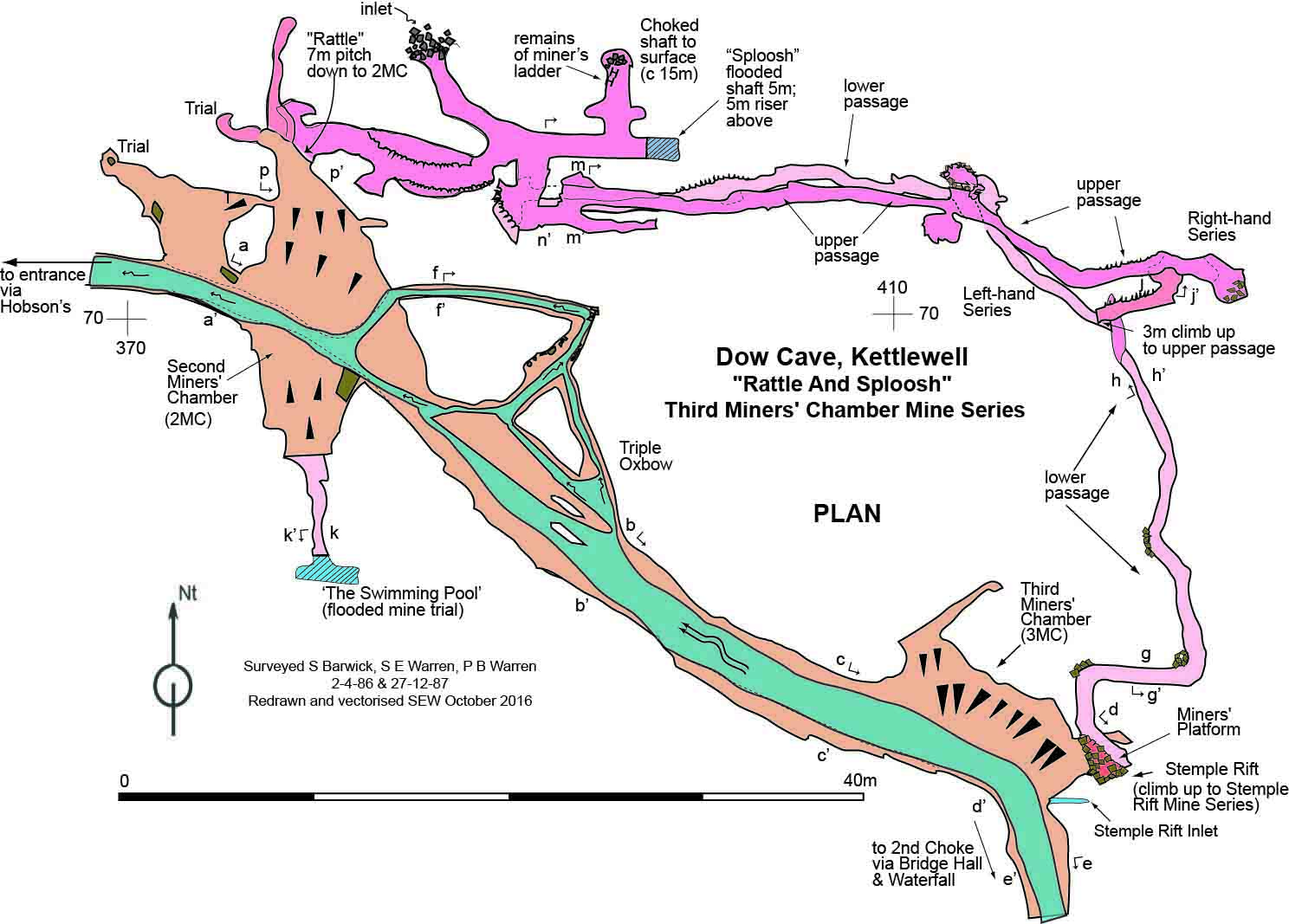
Fig. 23 Dow Cave: Rattle and Sploosh - Third Miners Chamber Mine Series - Elevation
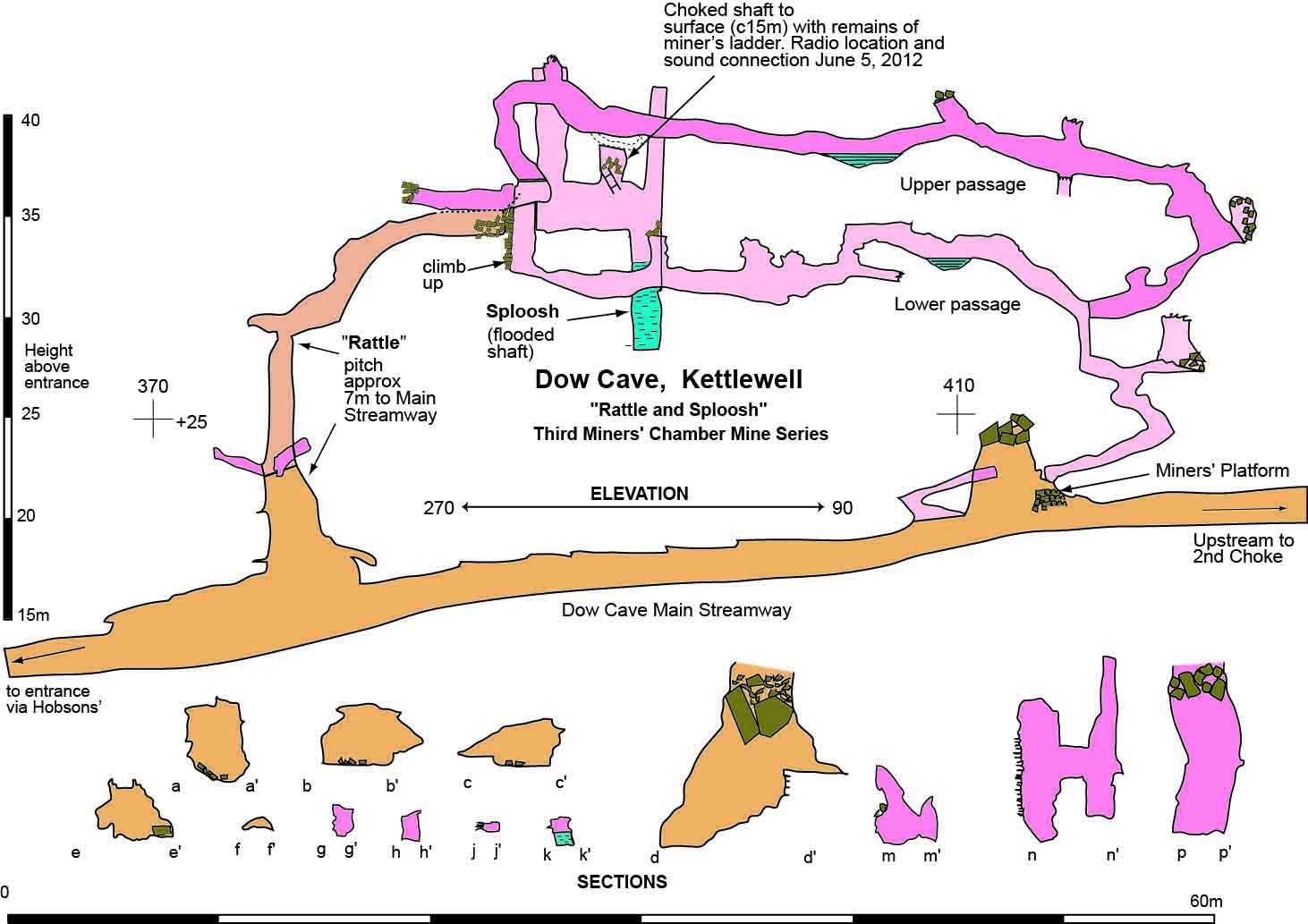
Fig. 24 Dow Cave: Stemple Rift Mine Series
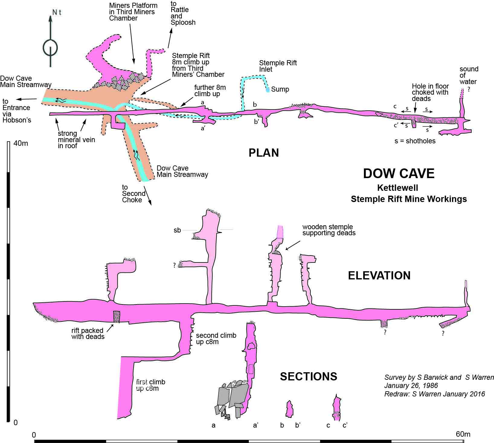
Fig. 25 Dow Cave: Sketch plan of the area around The Bridge
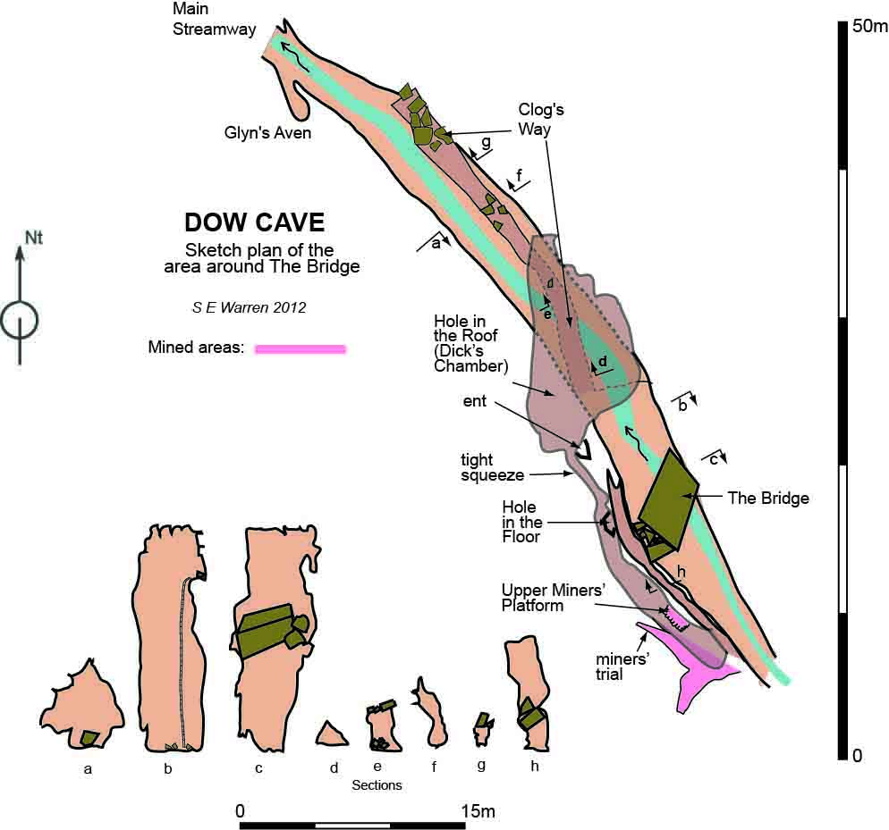
Fig. 26 Dow Cave: Sketch elevation of the area around The Bridge
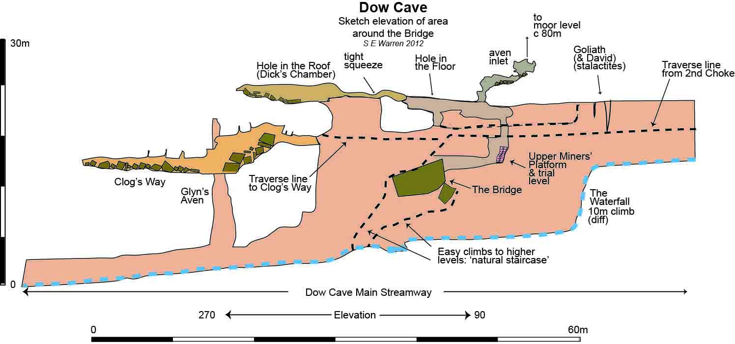
Fig. 27 Dow Cave: Second Choke and 1986 Albert Hall Extension - Plan
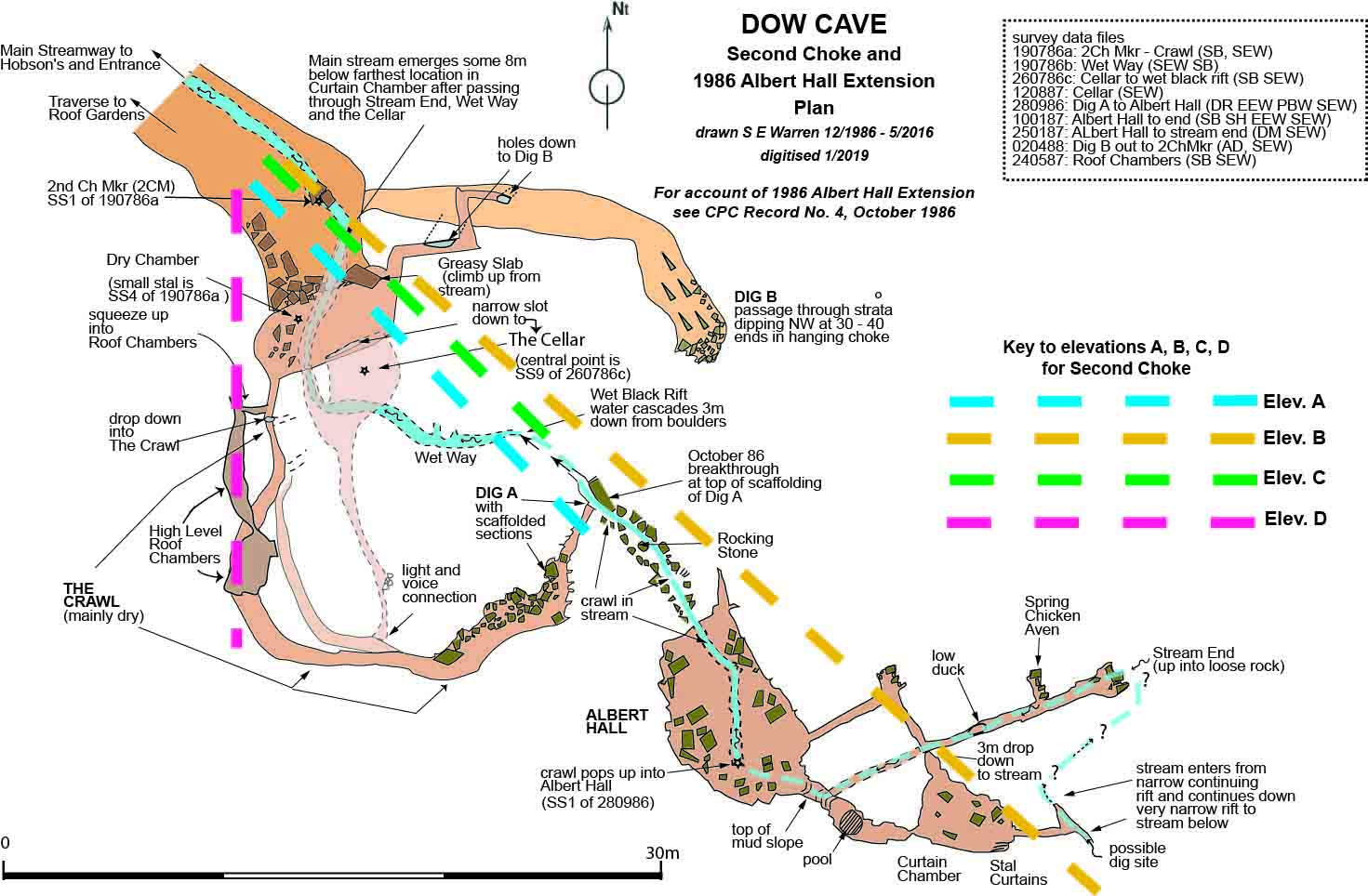
Fig. 28 Dow Cave: Second Choke: elevations A and B
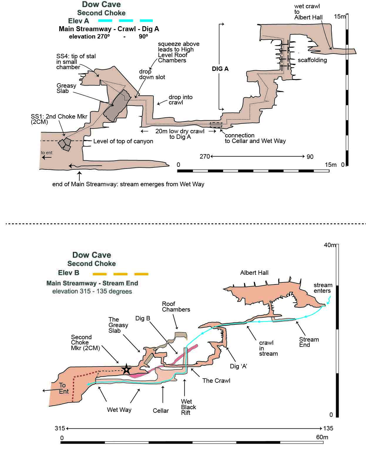
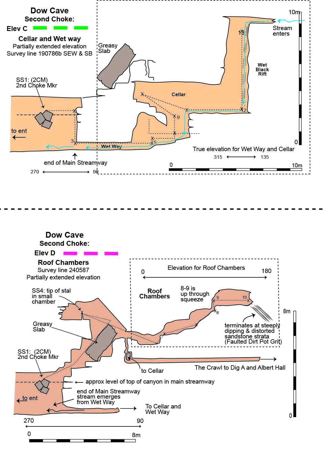
Fig. 29 Dow Cave: Second Choke: elevations C and D
Dowber Gill Passage and Providence Pot
Fig. 30 Original Dennis Brindle 1955 survey
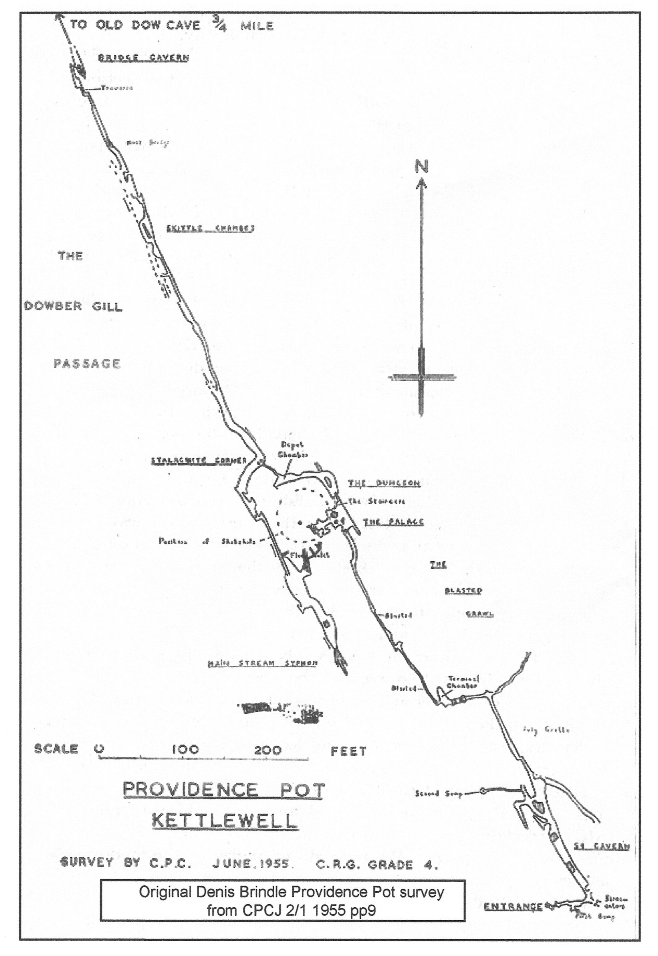
Fig. 31 Providence Pot 2010 survey: Plan
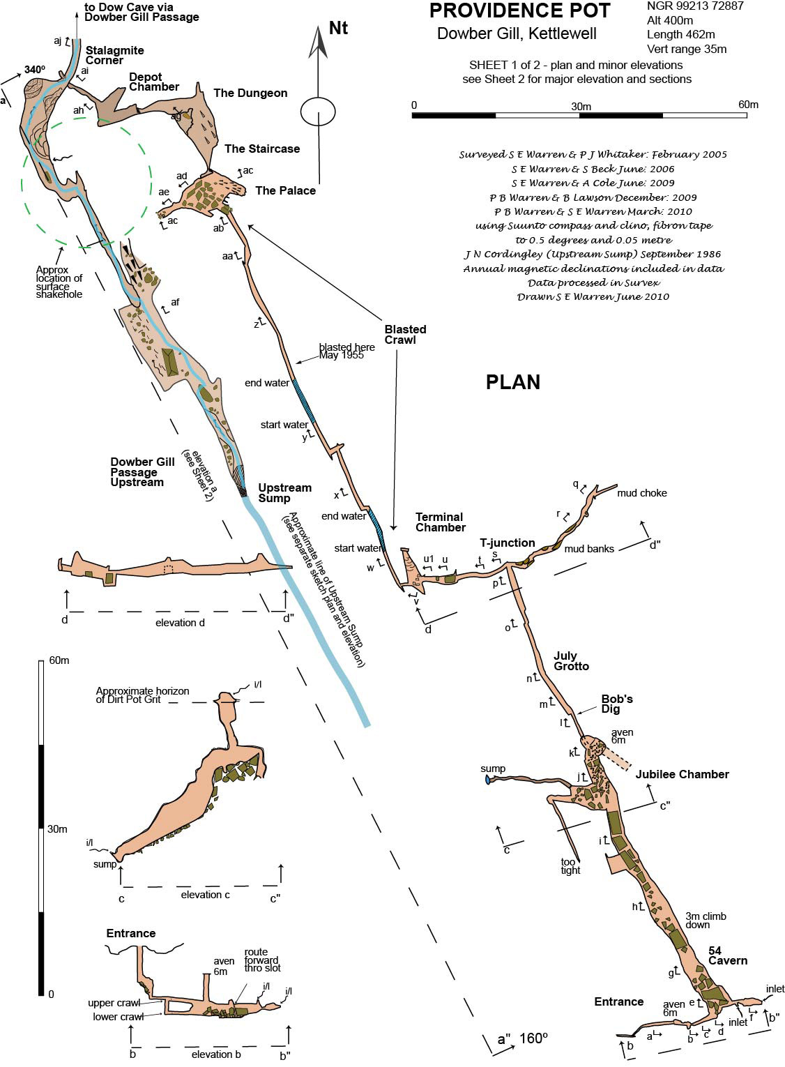
Fig. 32 Providence Pot 2010 survey: Elevations
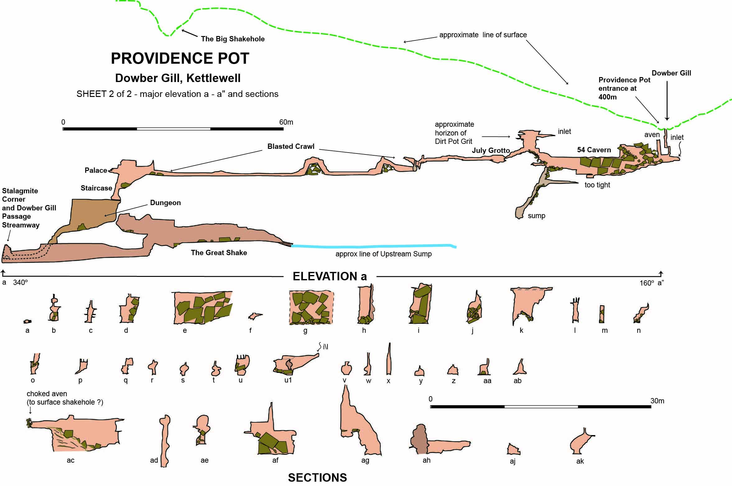
Fig. 33 Providence Pot sketches: Palace - Dungeon area: Upstream Sump
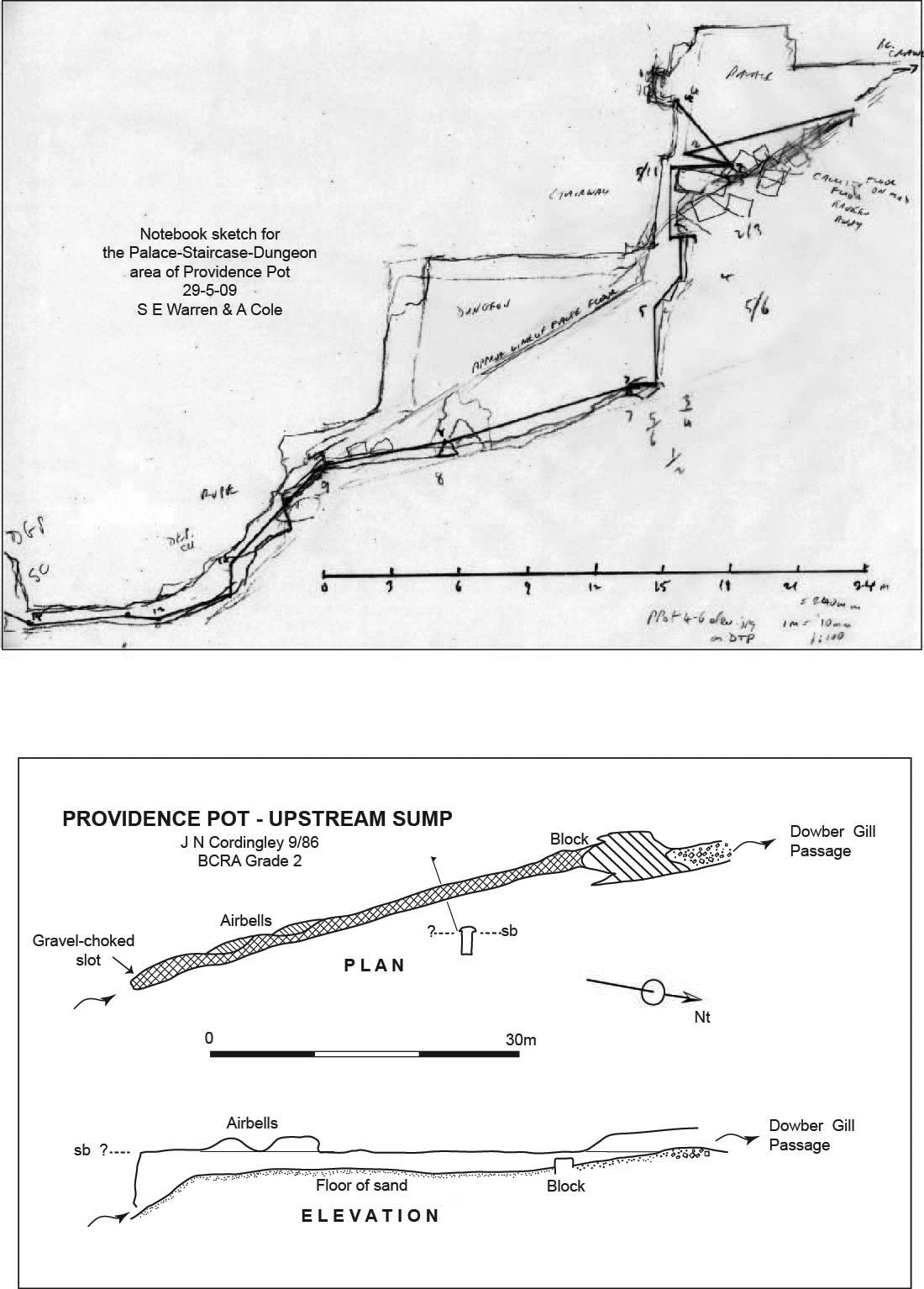
Fig. 34 Dow Cave - Dowber Gill Passage - Providence Pot System overview.
Based on an original idea from Patrick Warren
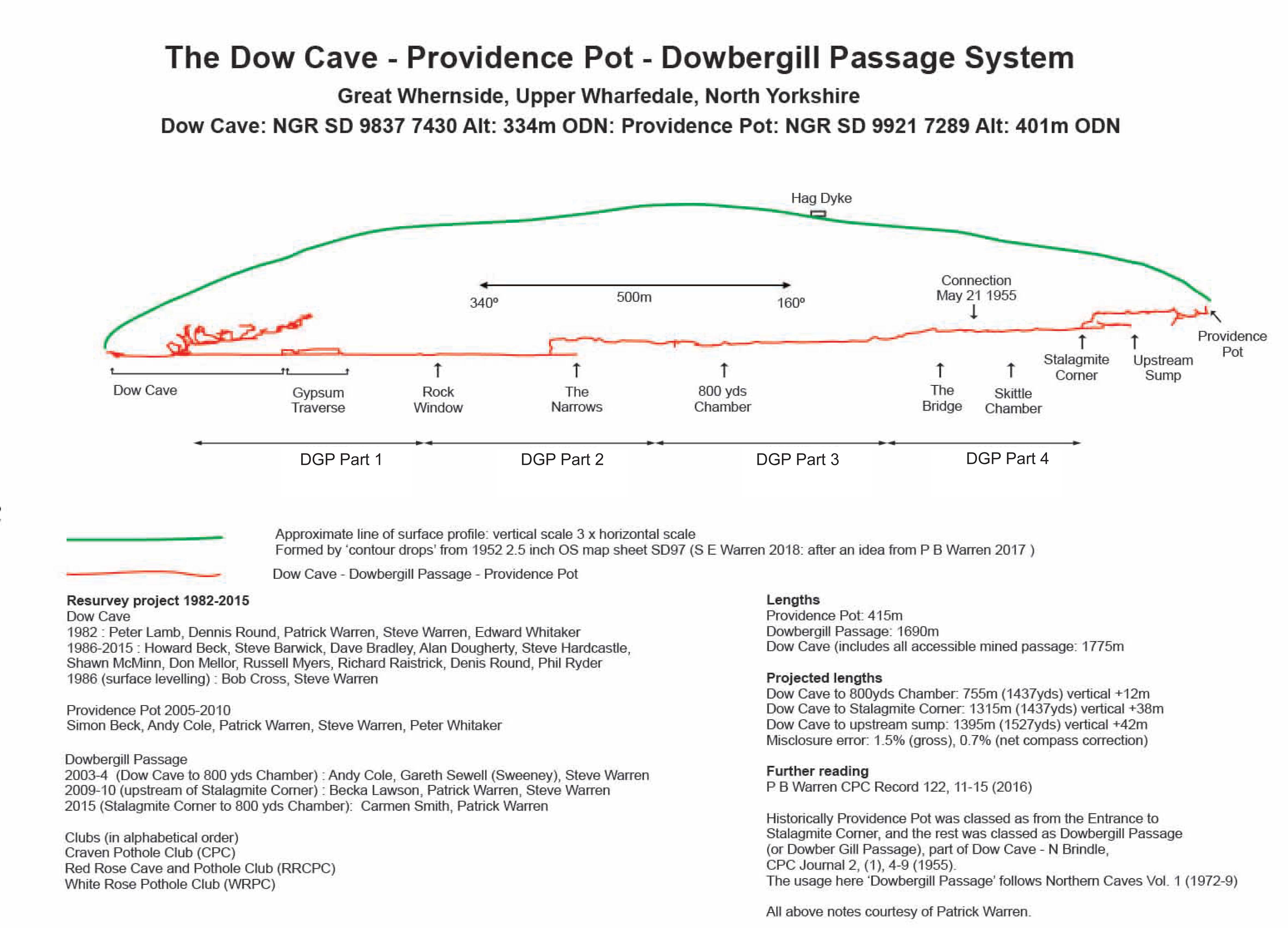
Fig. 35 Dowber Gill Passage: Part 1 (redrawn in Illustrator by Phil Ryder, 2018)
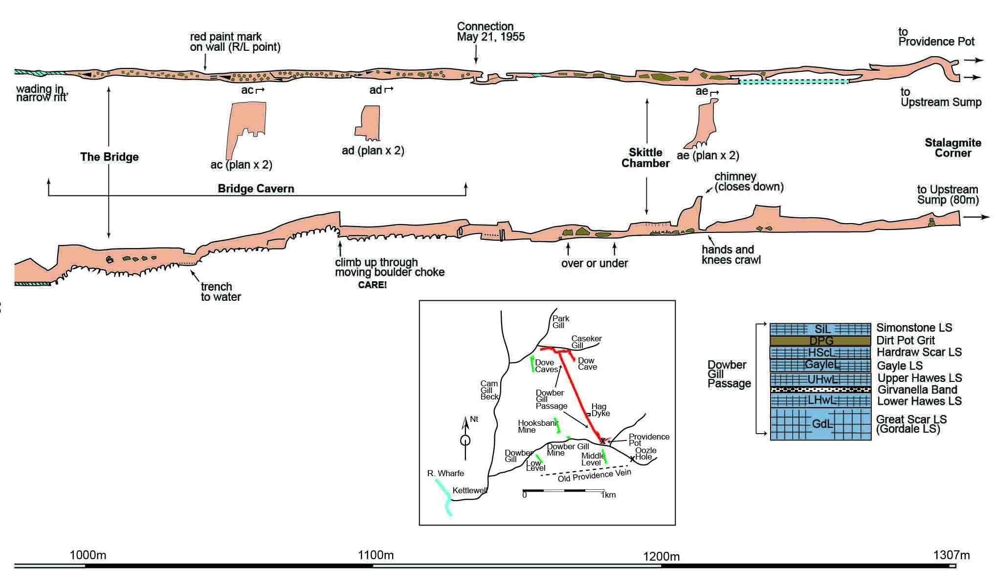
Fig. 36 Dowber Gill Passage: Part 2 (redrawn in Illustrator by Phil Ryder, 2018)
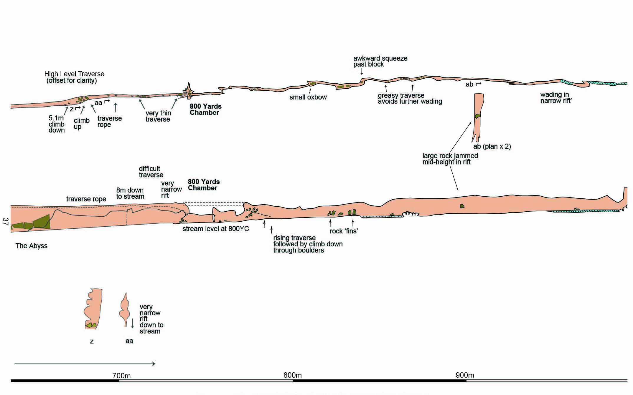
Fig. 37 Dowber Gill Passage: Part 3 (redrawn in Illustrator by Phil Ryder, 2018)
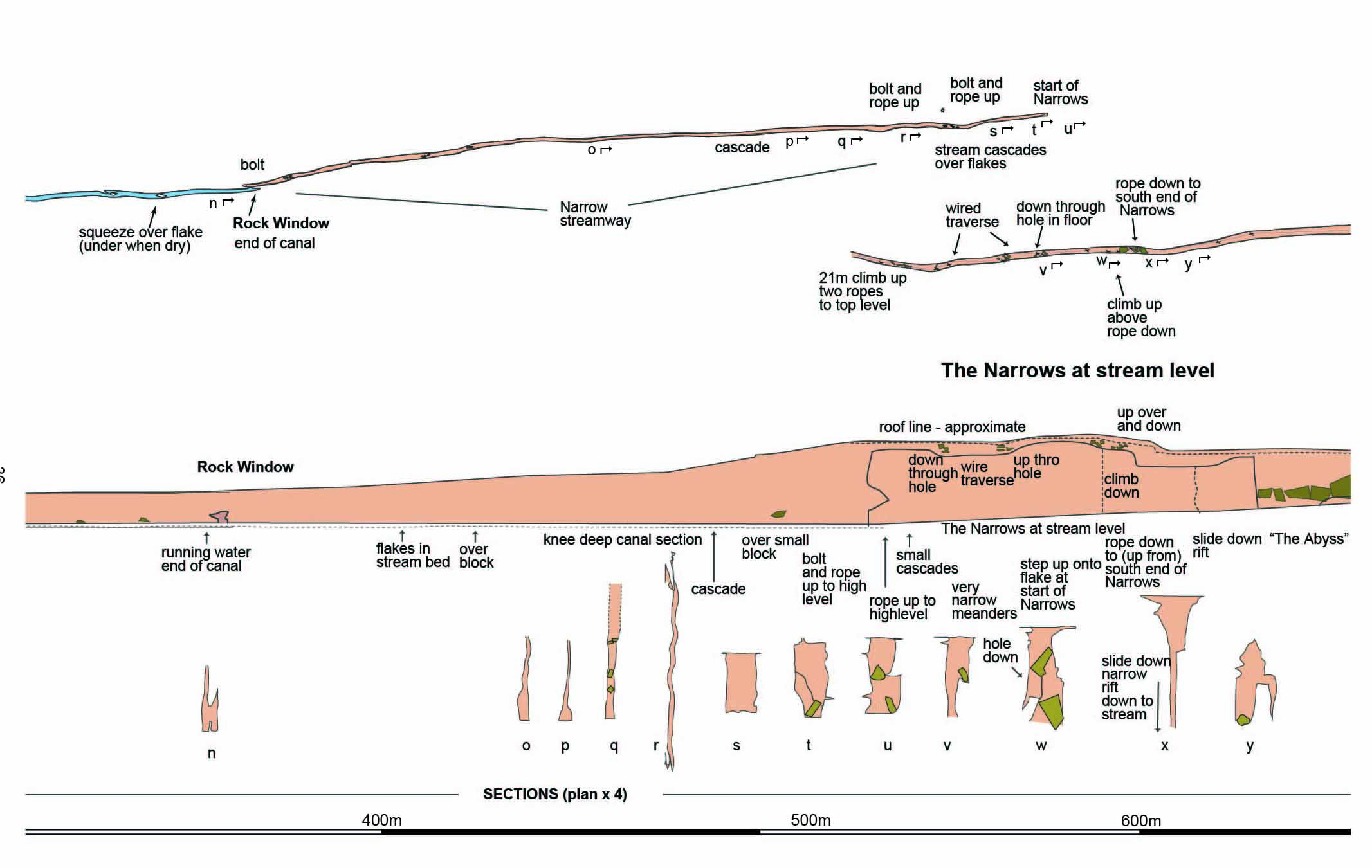
Fig. 38 Dowber Gill Passage: Part 4 (redrawn in Illustrator by Phil Ryder, 2018)
Any
shortcomings in the text are entirely my own.
If you would like to get in touch or add information, there is an email
address:
mudinmyhair@btinternet.com
Steve Warren
Website created by WarrenAssociates 2012
Website hosted by Tsohost
Copyright © Steve Warren 2012