A Geology of Western Penyghent
The pages below are under development and will be updated on a regular basis.
Much of the information that follows was compiled for a publication which never saw the light of day. However, more detail on the occurrence of the Girvanella limestone is due in no small part to enthusiastic assistance and welcome companionship from Phil Ryder during a number of sometimes lengthy forays in the field.
The onset of FMD early in 2001 brought an end to an interesting and rewarding series of field excursions but it seems appropriate now to make the results of my investigations generally available on this medium. On another page will be found a similar report on a very similar area, that of Upper Wharfedale.
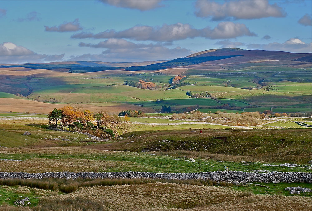
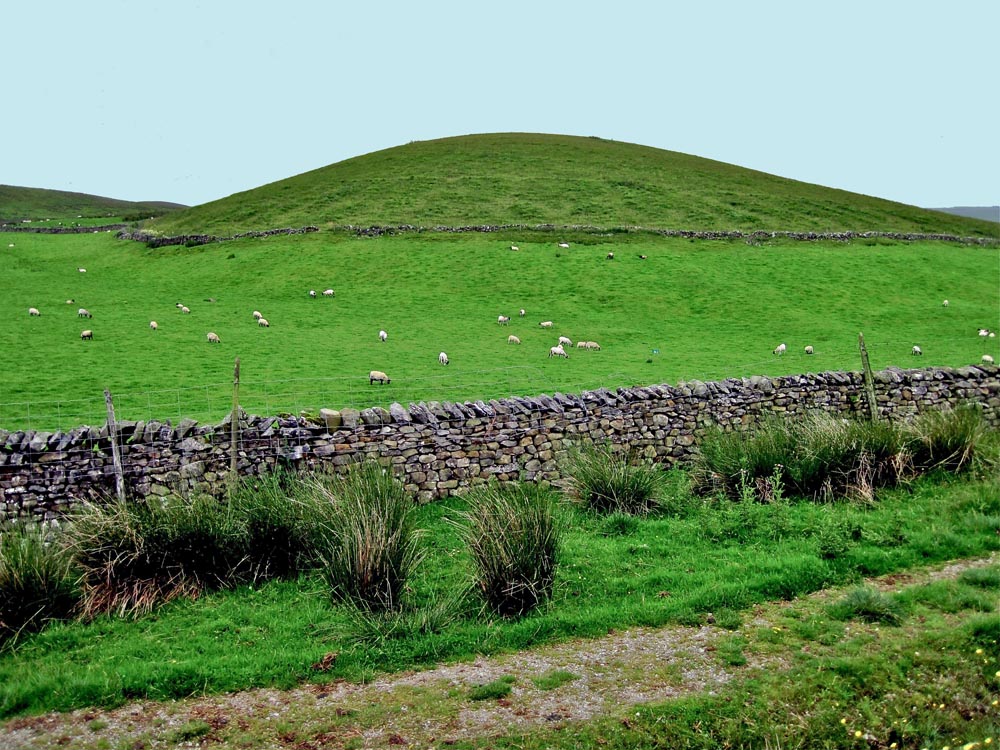
A general view across to the northern part of the Western Penyghent area looking over Alum Pot and Upper Ribblesdale from Borrins. Upper centre of the view is Birkwith Farm and gill with Old Ing Farm just behind and a little to the left.
To the left is Browgill and to the right the highest ground is High Greenfield. The top of the Great Scar limestone is prominent to the right but to the left of the view glacial deposits obscure the limestones. Photo SEW November 7, 2010
The rocks
At first glance, the obvious aspect of the rocks around Penyghent is a monotonous sequence of thick limestone beds in which can be found occasional fossils. To the average caver the fascination lies in the pieces which are not there at all - the caves and potholes which interest us so greatly. In fact, when examined closely, the rocks reveal something of the story of their origin and of their subsequent history.
For example, the very fact that they contain few complete fossils was seen by T McKenny Hughes as a result of "the accumulation of fragmental remains ... of the hard parts of organisms that swarmed over the sea bottom...." (Hughes 1908). Many geologists have examined and written about the limestones but the notes below refer largely to aspects observed in the field by myself.
The geologists
Before Hughes provided his delightfully readable account (Hughes 1908 op cit), John Phillips had published a monumental and entirely original work on the geology of Yorkshire (Phillips 1836). Officers of the Geological Survey followed to draw up the six-inch sheets of the nineteenth century. A detailed and definitive text was introduced by Professor Edmund Garwood and his colleague Miss Edith Goodyear in which a general palaeontological succession was established (Garwood and Goodyear 1924).
Many others have gathered together further details, including Wager (1931), Schwartzacher (1958) and Doughty (1968), they have provided a wealth of information on the lithology and structure of the rocks.
The cavers
With regard to caves and potholes, none of those geologists were quite so perspicacious as Eli Simpson. In fact, most of the early geologists shied away from venturing so far as direct investigation of underground exposures. In 1935 this remarkable man Simpson, “Cymmie” a caver through and through, published some profound comments relating cavern formation to the shale bands contained in the limestones (Simpson 1935), and see Appendix 1. Dr. Marjorie Sweeting also had ideas about cavern formation, contrasting somewhat to Simpson's. She suggested that the occurrence of most of the caves and potholes was controlled by geomorphologic features in the shape of 'erosion surfaces' (Sweeting 1950).
Later in the 20th.C., Waltham came on the scene to pick up the threads of Simpson's ideas, and of other members of the once exalted, and still respected, British Speleological Association, One of these was Atkinson who saw a link between joint types and cavern formation (Atkinson 1963). In a correlation of many sources, and adding his own observations, Waltham has questioned some of the previous notions about deposition of the limestones and about the formation of caves (Waltham 1970, 1971).
Geological structure
The area forms a small part of one of the least disturbed regions of the Northern Pennines, a fault bound block or 'horst' - the Askrigg Block. Throughout much of geological history the structure has been dominated by the presence at depth of a very substantial and structurally competent mass, the Wensleydale Granite.
This was predicted by Bolt (1967) after extensive geophysical surveys and confirmed in a borehole at Raydale at a depth of 495m (Dunham 1974).
Faults and folds
Because of its structural stability the area is relatively free from faults and folds, compared to the Craven Fault Zones around Stainforth and the district to the south, the Ribblesdale Fold Belt and the Craven Lowlands. One or two minor faults can be found; for example, in Jackdaw Hole a shale bed near the bottom is thrown down to the south, by about 30cm, by an east-west fault which is offset about 60cm by a north-south fault. The latter fault manifests itself as a small depression under the wall a few metres away and it was projected towards Hull Pot on the early six-inch geological sheet.
Further south, a fault line passing through Churn Milk Hole, Gavel Rigg Hole and Larchtree Hole probably acts as a conduit channelling underground waters towards the resurgence at Brantsgill (see also Myers J O 1963). The Main Chamber of Sell Gill Hole has its origins on a fault line and there are other less certain or less prominent occurrences of minor faulting.
Bedding and dip
The limestones are substantially horizontally bedded but with a gentle tilt to the east attributed to post-Cretaceous movements of the Alpine orogeny. The net result is that the limestones of Western Penyghent dip at around two degrees to the north and east; consequently the underground drainage has a tendency to be up-dip.
There are some inconspicuous variations in dip which may be deduced only from the relative altitudes of marker beds.
Jointing
An important structural feature is the extensive jointing present to varying extents in the limestone beds. Several of the pots, Cross Pot and Penyghent Long Churn for instance, exhibit control by jointing. In Jackdaw Hole the effect of jointing has been to propagate the collapse of the sides of the hole through a number of beds.
In such a clear exposure it can be seen that the joints fall into two sets at right angles to each other, trending NNE and WNW. Doughty (1968) has suggested that they were due to the release of 'strain energy' after regional, east-west, compressive forces of uncertain date.
The geological succession
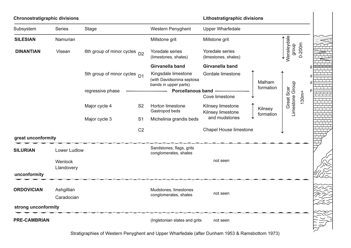
Figure 1. The general succession according to Dunham et. al. (1953) correlated with Ramsbottom's recently suggested stratigraphic divisions (Ramsbottom 1973). It differs in minor detail from the revised nomenclature proposed by George et. al. (1976). Fundamentally, the succession is common throughout the Craven limestone district.
The nature of the limestones and associated strata varies somewhat from west to east and this was defined by Dunham and Ramsbottom in their respective papers. Western Penyghent refers to the Ribblesdale- Ingleton area whilst Upper Wharfedale refers to the Malhamdale - Kilnsey - Littondale - Upper Wharfedale - Langstrothdale areas.
The basement rocks
The lowest rocks are an ancient assortment of grits and slates, with a little limestone, all highly folded and deeply eroded at the original surface.
Some of these are clearly exposed along the roadside around Sherwood Brow and Studfold, around Austwick, at Helwith Quarry and in Douk Gill.
The Great Scar Limestone
Above the basement rocks lie some 200m or so of thick bedded Carboniferous limestone. It is of special interest to us as it comprises the strata likely to be encountered by the caver prospecting on Penyghent being the sequence in which all the major caves and potholes are found: this is the Great Scar Limestone. It includes a number of shale bands, variable in thickness and extent, which are prominent only in underground exposures. The junction between the basement and the Great Scar Limestone can easily be examined in Douk Gill, by the wall about l00m downstream from the cave. However, the farmer is not always kindly disposed to visitors and he is unlikely to allow access. A more convenient place to see the junction is at Thornton Force, Kingsdale. The Great Scar Limestone occurs as a number of thick (c. 10m) beds of light-grey, white-weathering, occasionally fossiliferous and sometimes dolomitic, bioclastic limestone. Most of the beds are visible along the sides of the Ribble valley giving the characteristic step-like scars of a well-bedded harder rock, limestone beds, with thinner less competent layers, shale beds. The limestone is remarkably pure and chemically it consists of up to 99% calcium carbonate. (Schwartzacher 1958). it is estimated that about 50% is made up of recognisable organic debris, crinoid ossicles, shell fragments and foraminifera, in a matrix of recrystallised calcite mud.
The most common impurity is silica, as quartz crystals or as chert nodules. Stylolites, pressure solution phenomena, are often found in clean-washed underground exposures. They become more frequent at greater depths as in the lower stream passage of Sell Gill Hole. Basically these rocks were laid down in the energetic environment of a shallow transgressive Carboniferous sea. From time to time the depth of water (normally around 3-4 metres) varied so that deposition was of a different nature, allowing the shales to accumulate. Schwartzacher (1958) noticed current bedding adjacent to some of the bedding planes which implies a change to another energy regime. An extensive but thin coal seam has been recorded at Meal Bank, Ingleton: at Notts Pot on Ireby Fell, and at Ribblehead (Turner 1967): Thus on occasion the environment must have been above sea-level as the coal seam indicates plant growth. It has not yet been observed in our study area. Always, it can be deduced, a shoreline was not too far distant. At some levels, for example an exposure at the stream entrance to Sell Gill, a hummocky and potholed appearance of the upper surface of a bed is indicative of sub-aerial erosion - a palaeokarstic surface.
Fossil bands and marker beds
At various horizons within the Great Scar Limestone are found concentrations of fossils, in particular, a distinctive 'cockle-shell' type - Davidsonina septosa (Cyrtina septosa of Garwood). Originally it was thought to have accumulated some 30m below the top of the Great Scar Limestone. Recently it has been shown to occur at several other levels (Doughty 1974). A good place to see these fossils is in the stream-way leading to the top of the 43m wet pitch of Sell Sill Hole.
Two distinct 'marker beds’, or bands, the Porcellanous Band and the Girvanella Band are associated with the Great Scar Limestone (Figure 1). They have been fundamental bases for mapping in the relatively uniform sequence of the Great Scar Limestone which is otherwise poor in fossils. They represent widespread conditions favouring specialised communities. (Rayner 1953).
The Girvanella Band
Originally described as 'almond rock' by Hughes (1900) from its appearance, the Girvanella Band (GB) is a band of very dark or black bituminous limestone containing Girvanella nodules or oncoids. The nodules represent a symbiotic intergrowth between three species of lowly plants and animals, including the alga Girvanella which forms concentric rings around shell fragments (O'Connor 1964). Garwood and Goodyear (1924) claim to have seen the band at Jackdaw Hole but this may have been an outlying fragment as it has not yet been seen. The Girvanella Band occurs at the top of the Great Scar Limestone where it is taken as the boundary between the lower limestones of D1 age and the higher limestones of D2 age, the Yoredales. Locations where the GB can be seen clearly, i.e. the Girvanella nodules are distinctive which is not always the case, and which have examined are shown on the attached sketch map Fig. 2 (not currently available - under revision}
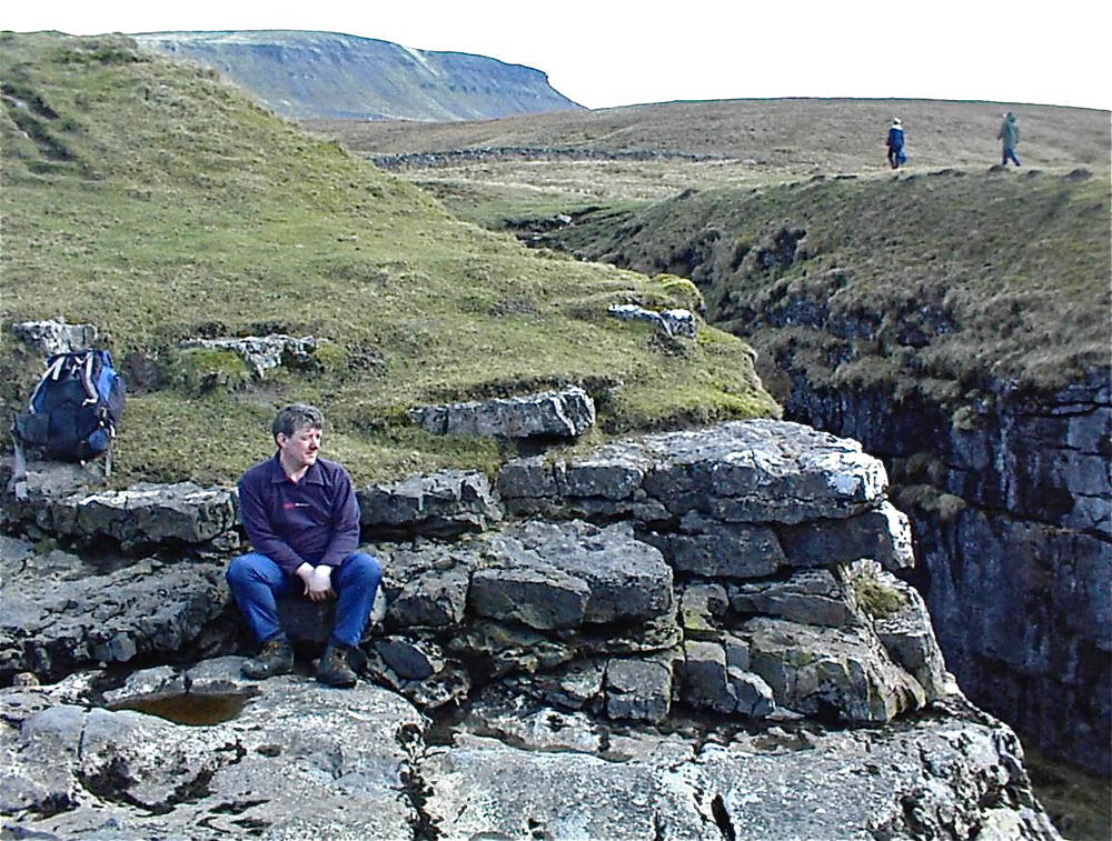
Left: Phil Ryder is sitting on an outcrop of the Girvanella Band at Hull Pot.
-
Lockey Gill NGR 85707449 Alt. 384m: a few metres below the road bridge - see photograph.
-
Giants Graves NGR 85477316 Alt. 396m: near the stream sinks
-
Gingling Sinks NGR 85737020 Alt. 460m: see photograph
-
Hull Pot NGR 82417458 Alt. 387m: where GB forms the stream bed from just above the lip of the dry fall upstream for several metres: see photograph above
-
Calf Holes NGR 80417758 Alt. 357m: see photograph
-
Ling Gill Bridge NGR 80307495 Alt. 340m: a few metres upstream from the bridge- see photograph
-
Hesleden Bergh NGR 878750 396m: just below the lip of the excavated shaft; fine specimens of GB may be found in the spoil heap
-
Swan Dyke NGR 870743 Alt.396m: some 10m downstream from entrance to pot - see photograph
Less obvious or less certain occurrences are at:
-
Churn Milk Hole NGR 83567184 Alt 441m: at the lowest part of the hole in an undercut section
-
Gavel Rigg Hole NGR 83267189 Alt. 447m: near the bottom of the hole in an undercut section
-
Lost John's Hole NGR 67073 78631 Alt. 360: in the surface stream bed and right down into the entrance passage.
-
Larch Tree Hole NGR 82957200 Alt. 420m: upper part of south east side about 4m down from the surface, and in north east wall about 5.5m down from surface
-
Penyghent Pot NGR 82897332 Alt. 424m: probably above the lip of the entrance shaft
-
Little Hull Pot NGR 821744 Alt. 390m: there is a large block of GB near the entrance
-
Penyghent Long Churn NGR 811753 Alt. 387m: a little way down the entrance shaft
The GB may also be seen at:
-
Gaping Gill NGR 751727 Alt. 390m in the floor of Jib Tunnel
See also the The Girvanella Band section on this website.
Fig. 2 (not currently available - under revision}
The Porcellanous Band |
|
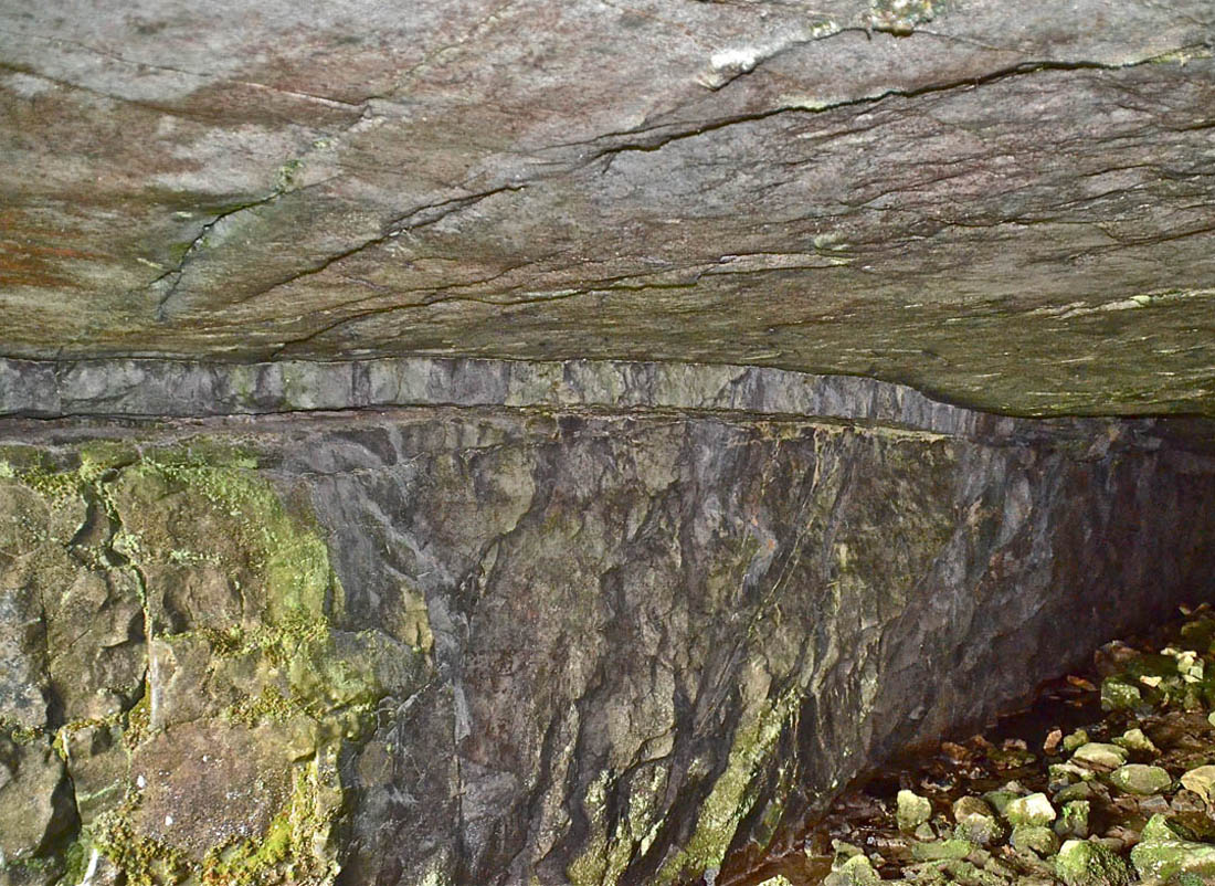
The porcellanous band is a bed of very fine-grained calcite mudstone or micrite often referred to as 'chinastone' layed down in a 'regressive phase' of changing sea levels. It is generally taken as a boundary between the S2 limestones and the D1 limestones as depicted in the geological succession of Fig.1 above. It is usually more conspicuous in underground exposures and it is a major feature in the Main Chamber of Gaping Gill where it occurs as two layers separated by some 3 metres. The lower bed is not as well developed as the upper and in places thins out completely. However the upper bed is very distinctive. It is clearly visible in the bottom of Rift Pot on the Allotment near Gaping Gill and it is assumed to underlie the sump passage of Sell Gill Hole. As surface exposure is commonly concealed by glacial drift a good place to see it is in Hull Pot Lane (Horton Scar Lane) at NGR 818731. See also the Porcellanous pages on this website. Dick Glover's papers may be seen as pdf downloads in the References below. Left: the porcellanous band is well exposed in the entrance passage of Scoska Cave. |
|
The Yoredales and higher beds |
|
|
Above the Girvanella Band lie some 200m of fossiliferous thin limestones, sandstones and shales forming the Yoredale Series. They are visible in Hull Pot Beck and on the slopes of Penyghent and these beds are often very fossiliferous. |
In Hull Pot Beck and Alum Pot Beck large corals and brachiopods can be seen in profusion. Above the Yoredale Series, the flat summit of Penyghent is formed by a bed of coarse sandstone usually assigned to the Millstone Grit Series. |
Glaciation |
|
It would seem that the thin-bedded and easily eroded Yoredale beds down to and often including the Girvanella Band were 'planed-off’ during the glaciations of the ice-age, leaving a prominent terrace along each side of the Ribble valley. Such terraces, which are prominent in many of the dales, were described as belonging to the '1300 foot erosion surface' by Sweeting (1950). It is on such areas where typical karst land-forms are exemplified (Sweeting 1972). A most significant feature of Western Penyghent is the glacial drift which lies in great masses everywhere, often as drumlins as we see in the Ribblesdale drumlin field in the north of the area. The drift deposits lying across the top beds of the Great Scar Limestone undoubtedly conceal cave entrances; they choke passages as at Jackdaw Hole, and they channel surface water flows as at Penyghent Long Churn. They also mask much of the hard rock geology thus perhaps accounting for the paucity of detailed information, in geological literature, for the immediate neighbourhood. Left: "Sykes" - typical of the smaller drumlins of the area. Photo SEW August 1 2010 |
|
Summary |
|
|
Limestones of S2 and Dl age constitute the geology of the caving country around Penyghent. A geological map has not been included because of this uniformity. The only horizons which can readily be identified are the marker beds and in this regard there is much scope for correlation. Similarly, lateral correlation of the shale bands will only be possible after many more underground exposures have been examined. The geological phenomena concerned with primary cave and pothole formation are principally jointing, minor faults, shale bands, and subject to further investigation, the porcellaneous band. |
A secondary control is breakdown due to jointing and fault crush zones. The cave-hunter/geologist investigating around Penyghent is at a grave disadvantage, because of the glacial drift covering so much of the district. For that reason it is easier to begin geological investigations where exposures are much clearer, on the east side of Ribblesdale perhaps. At the same time it is manifestly clear that future workers should incorporate the underground exposures so often neglected in the past. The cave-hunter should bear in mind the simple fact that many of the potholes of the Three Peaks area, and of Wharfedale too, commence at the point where surface streams cut down at the level of the GB into the more competent strata below. |
References |
|
Further reading. Waltham, A.C. 2007. The Yorkshire Dales.
Landscape and Geology.
Crowood Press 2007 ISBN
978-1-86126-972-0. Johnson,
David. 2008, Ingleborough.
Landscape and History.
Carnegie Publishing Ltd. 2008. ISBN
978-1-85936-187-0 (hb) ISBN 978-1-85936-187-7 (sb). Palmer, Arthur. 2007, Cave Geology.
Cave Books, Dayton Ohio. ISBN -13: 978-0-939748-66-2 (hardback). ISBN-10: 0-939748-66-5 (hardback). |
|
Apppendix i: A note on Eli Simpson |
|
|
Coming shortly |
|
|
|
|
|
Any
shortcomings in the text are entirely my
own. Steve Warren |
|
|
|
|
|
|
|
|
Website created by WarrenAssociates 2012 Website hosted by Tsohost Copyright © Steve Warren 2012 |
|